
Critical Areas
This is the most critical areas upgrade of your lifetime.
Clallam County neighbors, beware.
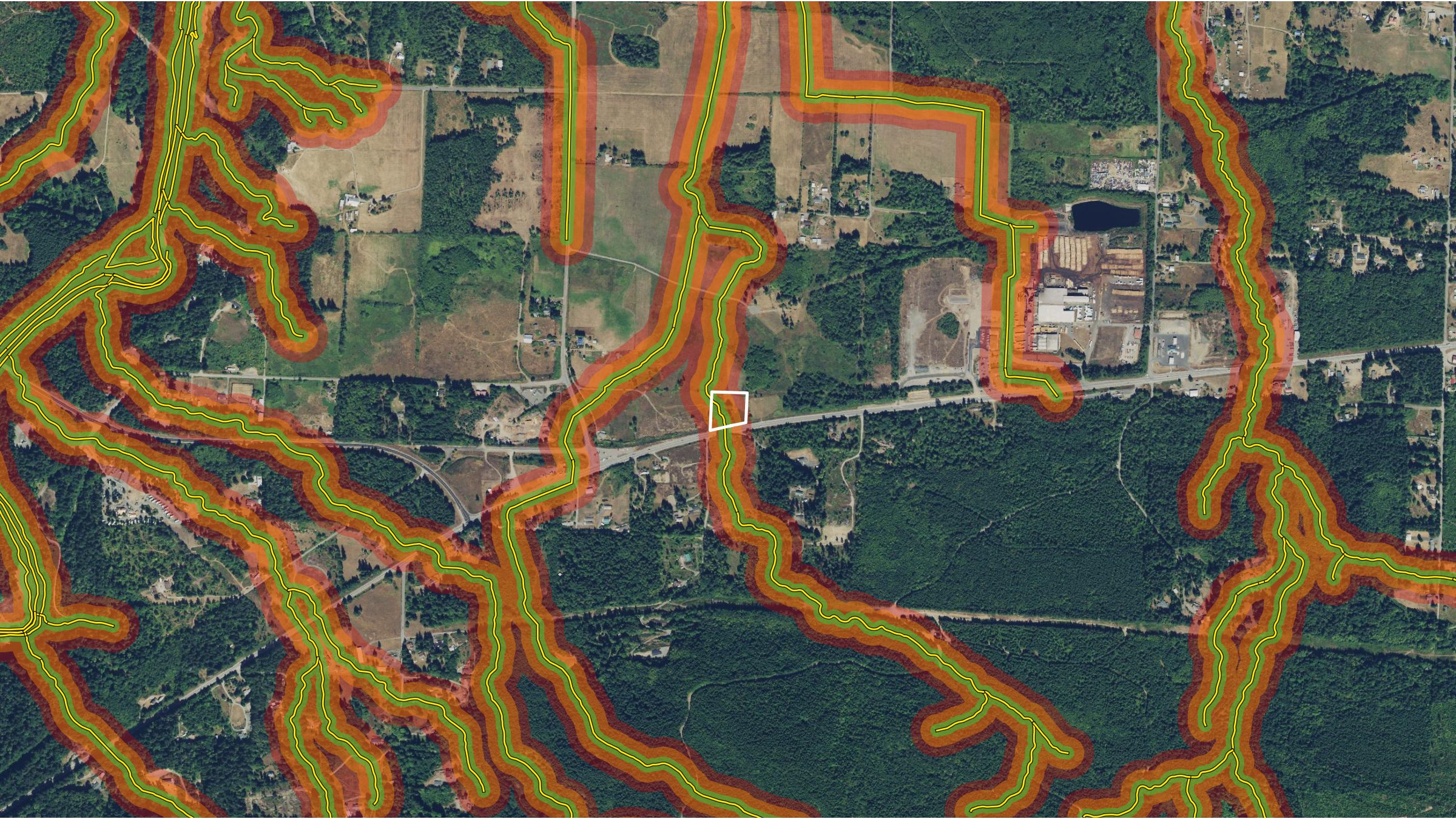
The County's October 13, 2026 draft of Chapter 27.12 would retype local streams to the state F, Np and Ns system and widen stream buffers to 150 and 100 feet.
- GIS estimate
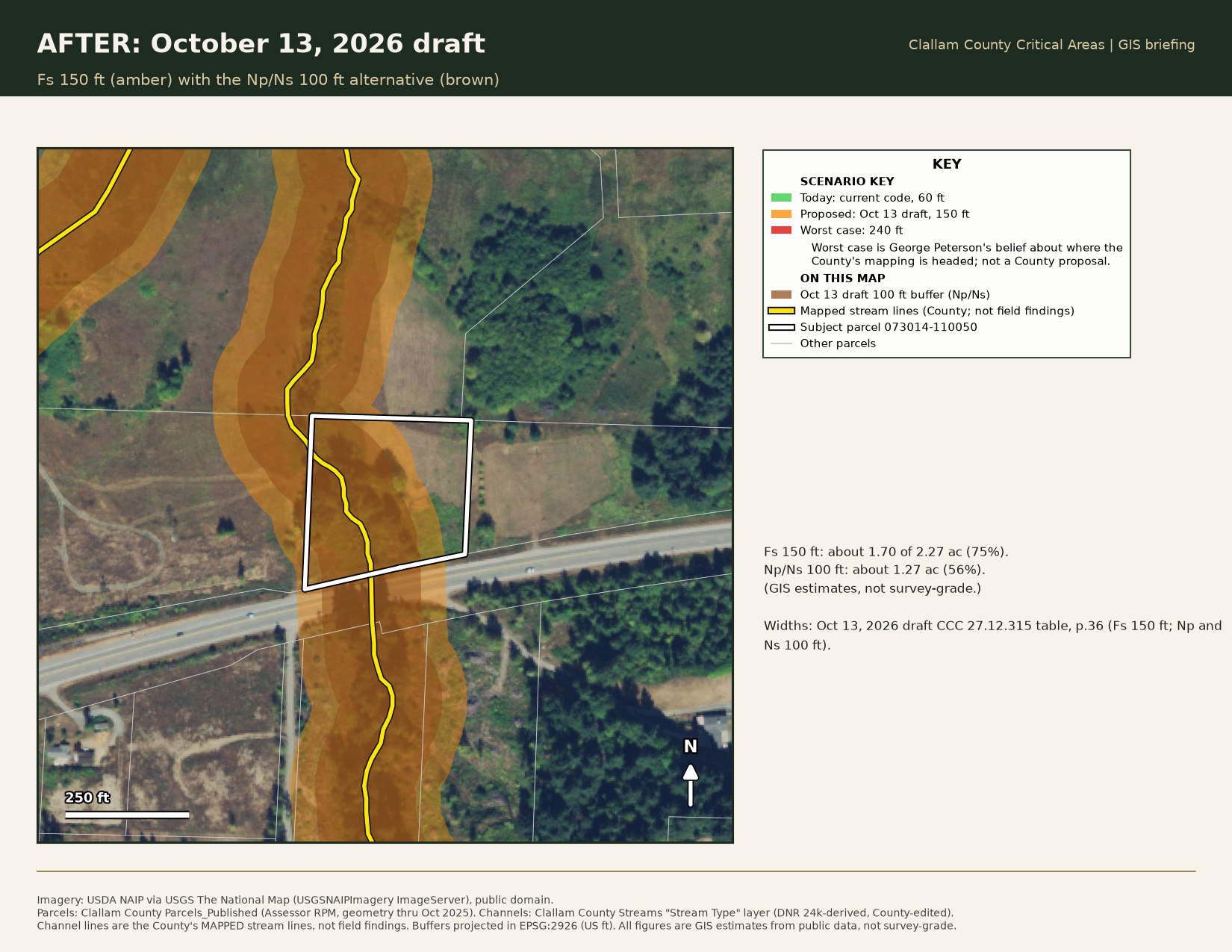
- 75%
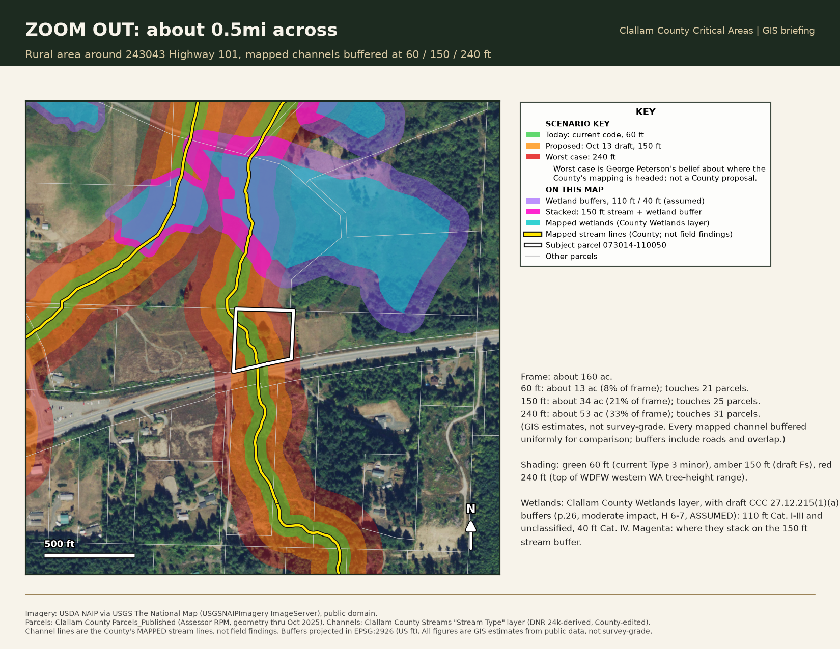
- of parcel 073014-110050 inside the draft 150 ft buffer
- GIS estimate
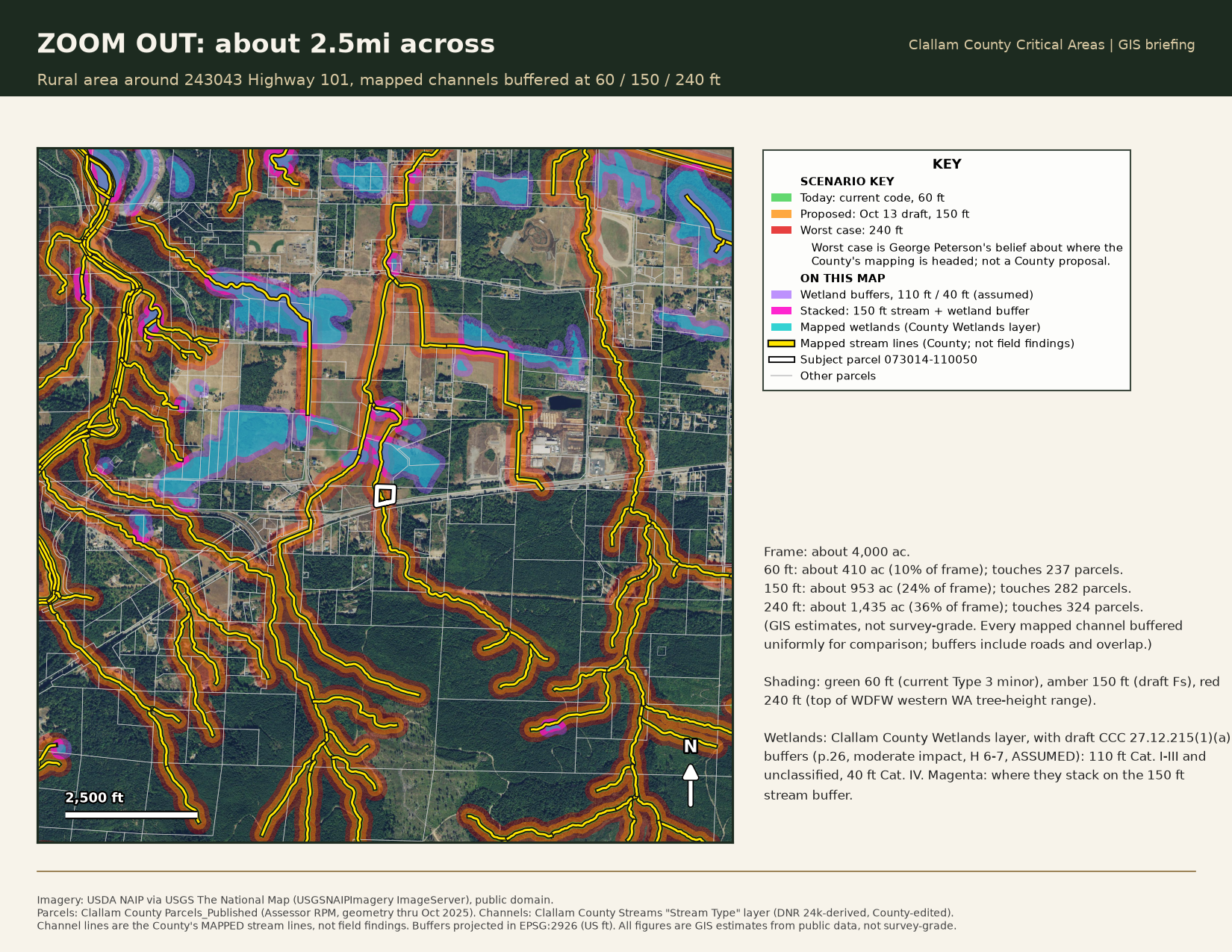
- ~953 ac
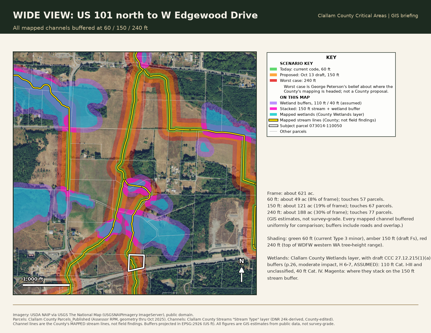
- under 150 ft buffers in a 2.5 mile frame around 243043 Hwy 101
- GIS estimate
- 282
- parcels touched by those 150 ft buffers
Estimates from Clallam County public GIS layers (County mapped stream lines, not field findings); not survey-grade.
Clallam County is rewriting its critical areas code. This page sets out what the October 13, 2026 draft changes, using one parcel's written record as the example. Quotations are taken from County correspondence, County code and the draft itself.
The standing example: 243043 Highway 101
243043 Highway 101 (Clallam County parcel 073014-110050) is the parcel Third Harvest holds under contract through a purchase-and-sale agreement. The land has been owned and used since at least 1926. The 1939 aerial photographs show worked fields on both banks of the drainage. A farm crossing has served this land for generations, and in its October 15 reply the County wrote that "Farmers frequently just drove through streams without establishing a permanent crossing."
Stormwater also reaches this parcel from 208 Laird Road, Third Harvest's adjoining parcel (073014-120000). As George Peterson has described to the County in writing, a curtain drain along the south side of 208 Laird Road, which predates Third Harvest's purchase, directs stormwater toward the creek.
The map does not match the record. The County's critical areas map shows this drainage as Type 3. In 2014, under Harvest Plan FPA2014-00005 for the parcel just south of US 101, the County wrote that the same drainage "is shown as a Type 3 per the Clallam County Critical Areas map," but that "based on the WDFW SalmonScape map, Clallam County has determined that this is a Type 4/5 stream as allowed per Section 27.12.050 CCC." The County has already corrected its own map for this drainage once. It has not reconciled that determination with the Type 3 it applies here.
The answers have been administrative judgments, not site findings. The County has said that "The County has no mechanism to modify stream types," and has referred stream typing to the Department of Natural Resources in an October 9 email and in October 14 and October 15 replies. It has pointed toward a variance, and an October 9 email stated that "the approval of a variance is not likely as the criteria has not been met."
In George Peterson's view, the direction is clear. A farm crossing used for generations is being held in limbo while basic questions go unanswered, which he believes already raises the question of a temporary taking. If the October 13 draft is adopted and applied on top of the current mapping, he believes that limbo could become permanent. He states this as his belief, not as a legal conclusion.
Risk 1: Five local stream types become three state types
The October 13, 2026 draft of Chapter 27.12 (a draft ordinance, not yet adopted) rewrites section 27.12.310(1)(a). Streams would be classified by the Washington Department of Natural Resources Forest Practices Water Typing system, Type F, Np and Ns, in place of the County's current Type 1 through 5 waters.
Five categories collapse into three. In the definitions section, 27.12.900 (page 94 of the draft), the whole current Type 1 through 5 definition set is struck. That includes the sentence: "Designation of Type 5 streams shall require review and confirmation by the Clallam County Habitat Specialist on a case-by-case basis." That local, case-by-case check would be gone.
The buffers are wide. The draft buffer table in section 27.12.315 (page 36) reads: Fs, 150 feet; Np and Ns, 100 feet; non-shoreline natural ponds and lakes under 20 acres, 100 feet. Buffers are measured horizontally from the ordinary high water mark. The draft allows a smaller buffer only "where the landowner can provide evidence that the tree-height potential is less than the standard buffer noted." The jurisdiction table extends County review to land within 200 feet of Type F, Np and Ns waters.
There is one written path out. The draft defines Type Np to include "streams that have been proven not to contain fish or fish habitat using methods described in Forest Practices Board Manual Section 23." That path also puts the work of proof on the owner.
Risk 2: The deferral loop
The County defers stream typing on this parcel to DNR. DNR's Dori Bongiolino has told George Peterson that this non-forest parcel is outside DNR's water-typing jurisdiction. So the question comes back to the County with no agency holding it. The critical areas ordinance is the County's ordinance, the map is the County's map, and the map error provision, CCC 27.12.050, is the County's own provision. The County's answer is the only one that counts.
Risk 3: A classification without a study
George Peterson has seen no documentation that this channel has ever been studied on the ground. He has asked the County in writing whether it will review the evidence on site and by video before any determination is final, and that question remains unanswered.
The evidence on the record points the other way. The County's own Type 4/5 determination under FPA2014-00005 covers the same drainage. The WDFW record shows a total fish barrier at the US 101 culvert, ending at a natural 2.5 meter bedrock fall. North of the highway, after blackberry removal that County staff said was allowed, the section running down to the crossing shows no creek bed and no channel.
In George Peterson's view, the best available science in this record is the evidence he has put before the County, including the County's own documents, not an unverified map layer.
Risk 4: The burden lands on the owner
County code already provides the fix. CCC 27.12.050 says map information "shall be advisory," and that critical areas "shall not include those lands where a qualified professional or qualified professional sources demonstrate to the satisfaction of the Administrator that maps or other information used to identify the location and extent of critical areas are in error." State guidance says counties "should clearly state that maps showing known critical areas are only for information or illustrative purposes" (WAC 365-190-080(4)(b)).
Even so, the owner is asked to carry the cost of disproving a map the County has already contradicted in its own 2014 determination. The draft adds to that burden. New section 27.12.315(1)(c) (page 37) provides that "the property owner shall agree to undertake restoration activities or authorize such activities to occur, by means of a restoration plan prepared by a qualified professional" before a permit next to degraded critical areas or buffers. In the same subsection, the existing sentence stating that "Clallam County shall provide information or technical expertise, where possible, in facilitating restoration activities" appears struck out.
Many residents in this county cannot afford engineered plans, habitat management plans and professional reports to answer requests like these.
One parcel, three buffers, and the whole drainage
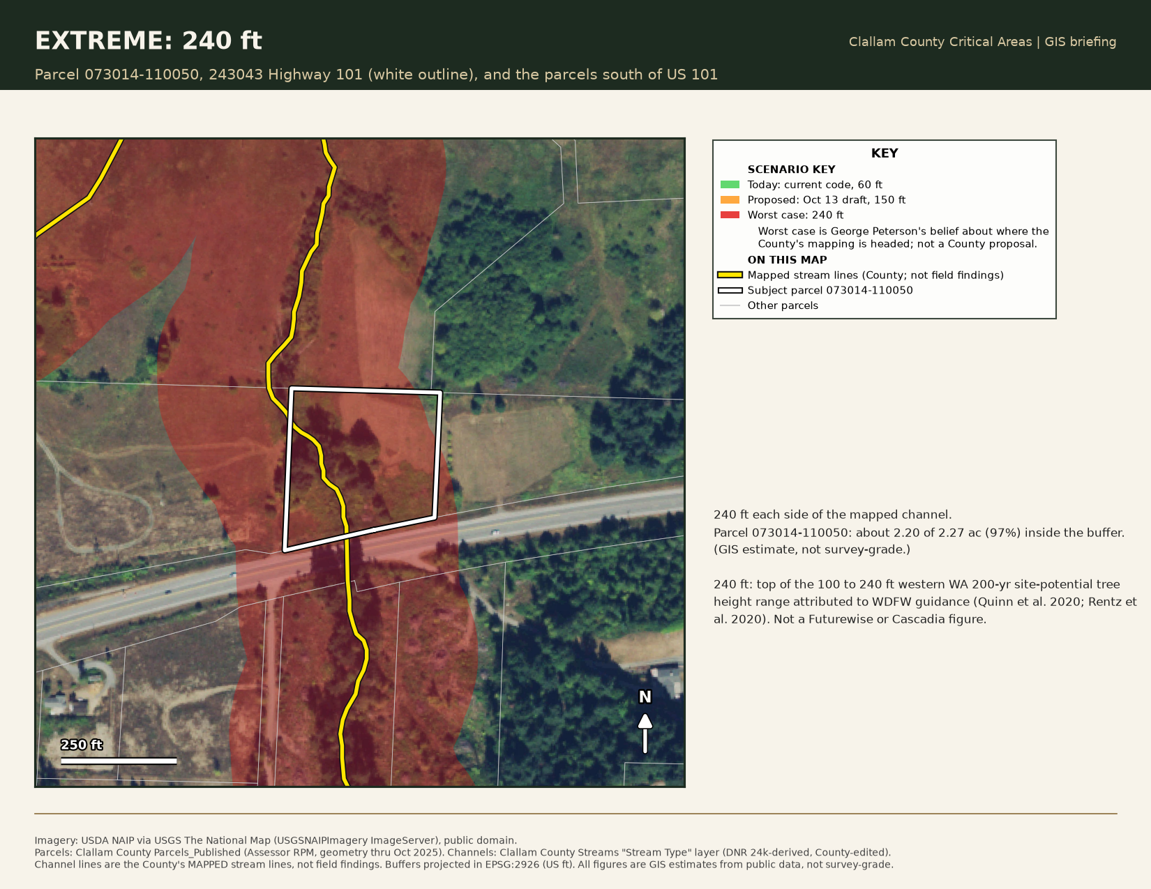
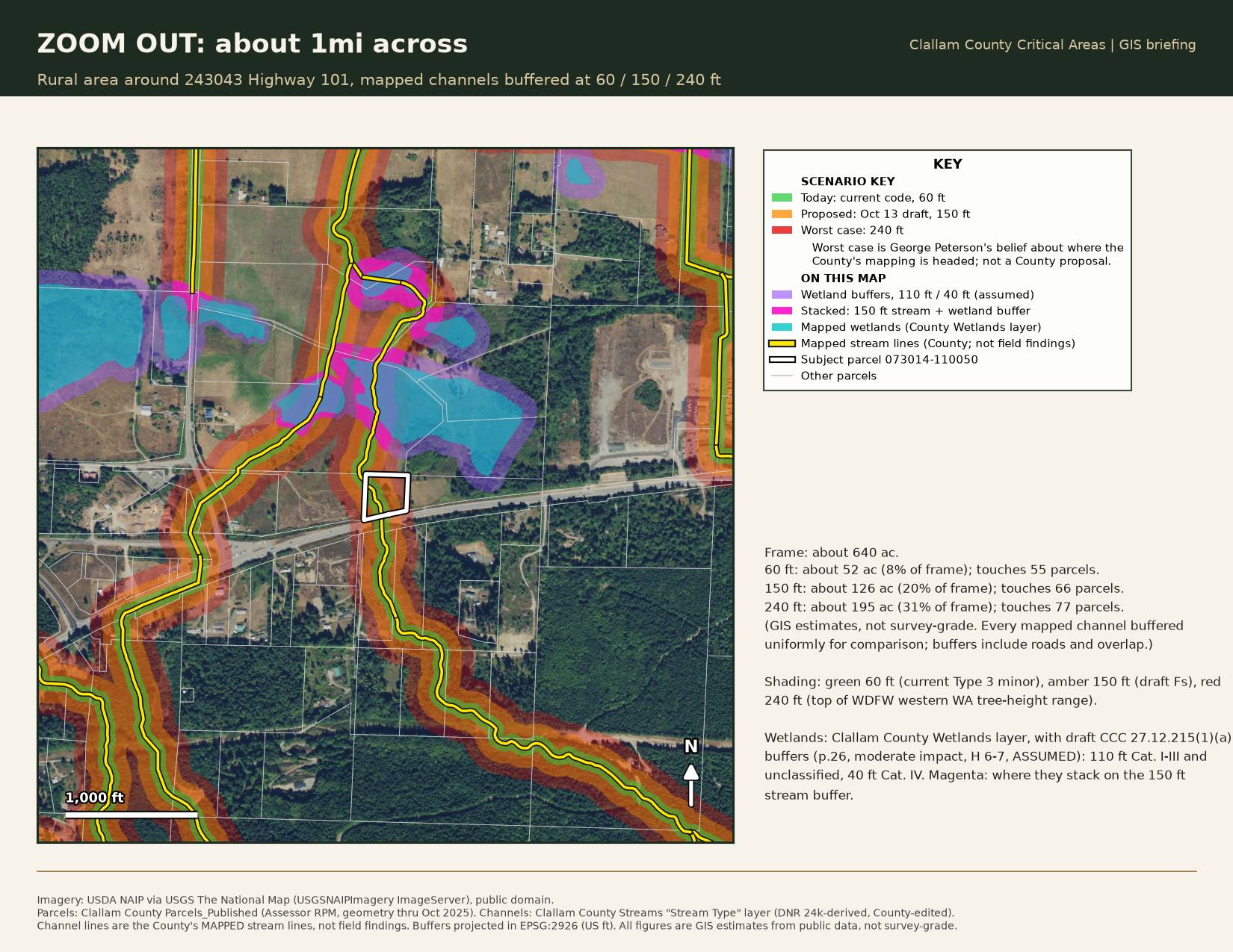
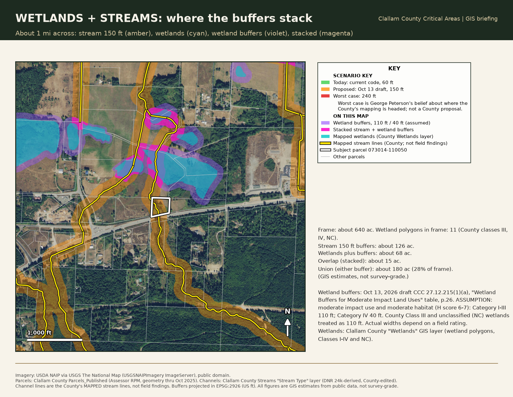
The maps below use 243043 Highway 101 (Clallam County parcel 073014-110050, 2.27 acres in County GIS), the parcels across the highway, and the wider rural area, on USDA NAIP aerial imagery. The buffers follow the County's mapped stream lines, which are not field findings: George Peterson reports that the north section of the parcel has no channel at all. Every figure is a GIS estimate from public data and is not survey-grade. Sources: Clallam County Parcels_Published, Streams (Stream Type) and Wetlands layers; imagery from USDA NAIP via USGS The National Map (public domain).
Download the briefing (PDF)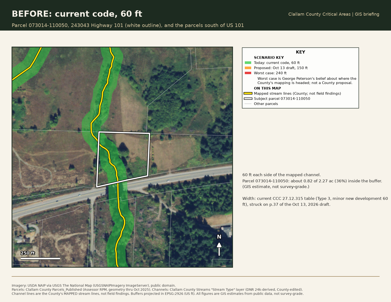
What it could cost an owner
If the expansion passes, repairing or crossing existing infrastructure on a stream typed as fish-bearing could mean a new engineered crossing, County permits and professional reports. Every number below is an estimate drawn from a public source, not a quote for any specific property.
New fish-passable crossing on a small private stream (box culvert or short bridge)
Estimate: about $85,000 to $130,000 per crossing, based on documented state-funded projects. Recent costs are likely higher.
Highway-scale fish-passage correction (for comparison only)
Estimate: WSDOT's average was about $5.3 million per project in 2018, and about $20 million for the remaining projects. These are public highway projects, not farm crossings.
Source: The Seattle Times, reporting WSDOT fish-passage cost estimates.
County variance heard by the Hearing Examiner (Type III)
Estimate: $1,541 planning review plus $2,800 hearing examiner fee ($1,400 for single-family dwellings). Fees only; no consultant costs.
Critical area certificate of compliance
Estimate: $154 for single-family residential and accessory uses; $308 for other uses.
Source: Clallam County Fee Schedule 300-A, as amended January 6, 2026.
County review of a critical area report or mitigation plan (for example a habitat management plan)
Estimate: $503 per report, up to a maximum of $980. This is the County review fee only, not the cost of preparing the report.
Source: Clallam County Fee Schedule 300-A, as amended January 6, 2026.
The taking question
It is George Peterson's belief that the County's treatment of this parcel raises serious constitutional questions. Under the Fifth Amendment, as he understands it, a regulation that destroys a property's highest and best use without compensation is a taking, and the United States Supreme Court has held that even a temporary taking that denies a landowner all use of the property must be compensated (First English Evangelical Lutheran Church v. County of Los Angeles, 1987). Under the Fourteenth Amendment, as he understands it, a classification applied to private land without any site-specific evidence is arbitrary government action that violates due process.
He states these as his beliefs about where this matter is headed, not as legal conclusions.
This page is not legal advice. If you have questions about your own property, talk to a licensed Washington attorney.
Read the draft yourself
Download the County's October 13, 2026 draft of Chapter 27.12, Critical Areas. It is a scanned redline: underlined text is added and struck text is deleted.
Download the October 13 draft (PDF)Something better than a taking
The County already has the code and the authority to fix this administratively. CCC 27.12.050 lets the Administrator correct a map error. CCC 27.12.040 lets a lawfully established use continue. The County has used those tools before, on this same drainage.
Let's work together on something better than a taking: a clear, written process for documenting historical use, deciding stream type on non-forest land, and correcting a map that does not match the ground. That would serve every landowner in this county.