
A Parable About A Farmer and A Fence
A farmer was told the future lay over the mountains. Everyone in the valley sold their tools and walked toward the pass. The farmer stayed behind and mended the fence, cleared the spring, and kept the barn dry. Years later the travelers came back down, tired and hungry, and the only warm place in the valley was the one somebody had bothered to keep.
That is the whole idea of Return to Earth. George believes the people who go out will need a place to land, to heal, and to learn how to live on a planet again. He would rather build that place now, slowly and honestly, than wait to be asked.
We are not claiming anyone has agreed to this. We are showing our work so that anyone who might agree can see exactly what they would be agreeing to.
Why Quillayute Airport
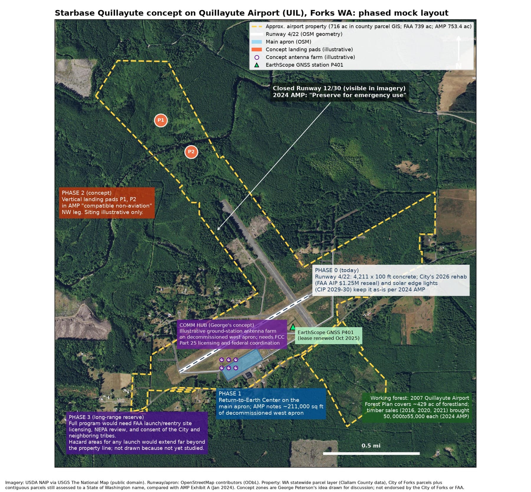
The candidate site is Quillayute Airport (FAA code UIL), about ten miles west of Forks. These are the facts as the public record states them:
- Owned by the City of Forks, which received it from the Washington State Department of Transportation in 1999.
- 739 acres in FAA records; the 2024 Airport Master Plan property map lists 753.4 acres.
- Runway 4/22 is 4,211 by 100 feet, concrete in good condition.
- Built in 1943 and commissioned in 1944 as a Naval Auxiliary Air Station.
- Field elevation 194 feet. Outside the state's modeled Cascadia tsunami inundation area.
- About 429 acres of the airport are working forest under a 2007 forest plan, with timber sales in 2016, 2020 and 2021.
Sources: FAA data via https://skyvector.com/airport/UIL/Quillayute-Airport and the City of Forks Airport Master Plan, https://forkswashington.org/wp-content/uploads/2025/01/Quillayute-AMP_2024.pdf
What the master plan actually says. You may have read that the plan would reopen the old crosswind runway. The adopted 2024 plan does not. It keeps Runway 4/22 at its current length, preserves the paved overrun "for future use", and keeps the closed runway "for emergency use." We would rather tell you that up front than have you find it later. (The City's 2025-2045 Comprehensive Plan repeats an older line about reopening that runway, copied from a 2006 encyclopedia entry; the adopted 2024 master plan is the document the City and the FAA work from.)
What the City is doing now. In 2026 the City is rehabilitating the runway and taxiways with FAA and state help, including a $1.25 million FAA grant announced in May, planning solar runway edge lights, working on the hangar and terminal, and talking with the Port of Port Angeles about passenger service. The airport also already hosts an EarthScope GPS research station and a National Weather Service balloon station. George believes Starbase Quillayute should fit around that work, not compete with it.
What Existing Starbases Look Like
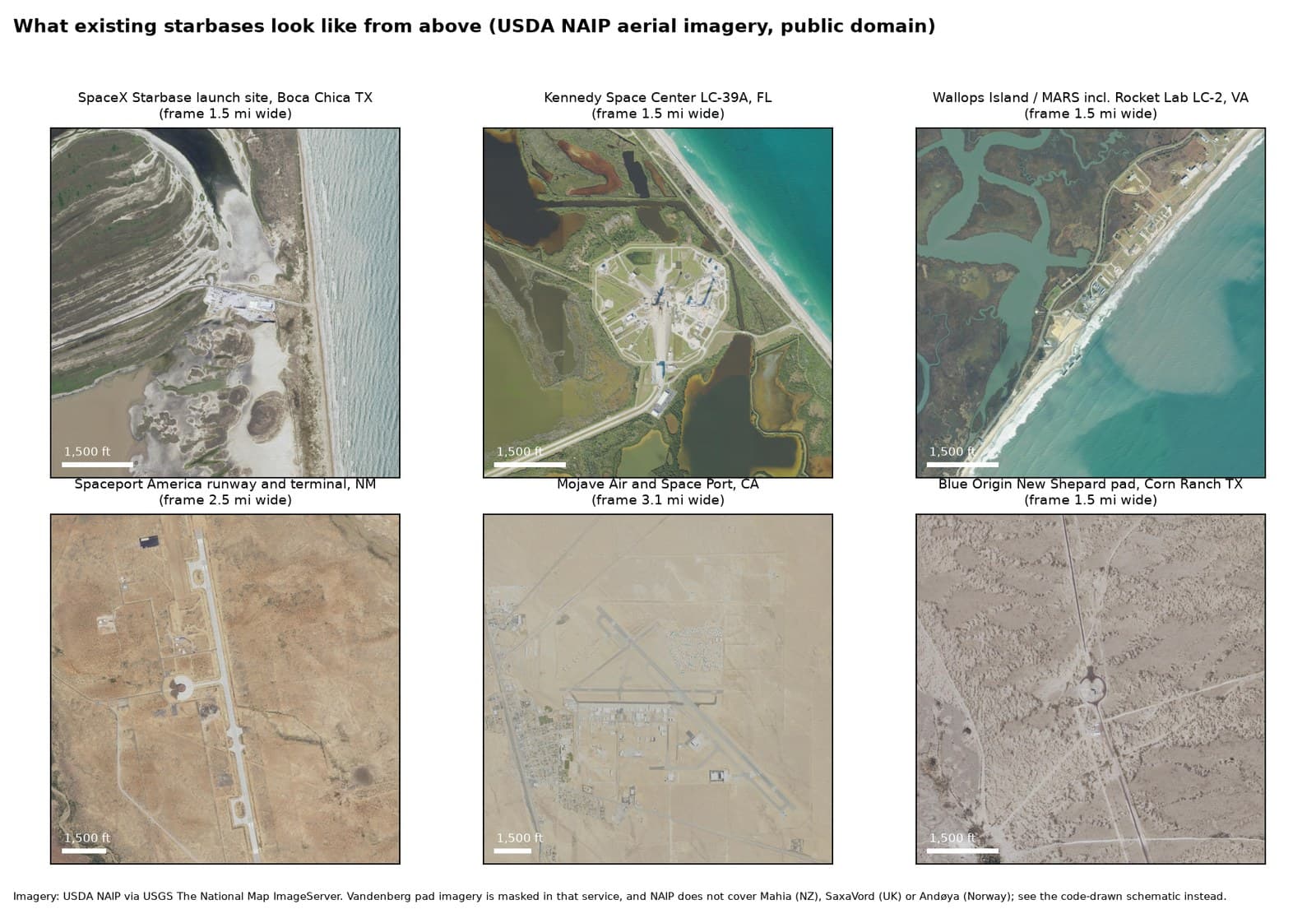
Spaceports come in every size. Edwards Air Force Base covers 301,000 acres. Kennedy Space Center covers 144,000. The Pacific Spaceport Complex on Kodiak Island, Alaska, sits on 3,700 acres of state land, and it is the closest cousin to what George has in mind: remote, coastal, northern and publicly backed. Quillayute is smaller than all of them.
That is why the plan is phased, and why the early phases are about returning, learning and landing, not launching:
- Today. The airport stays a general aviation airport, exactly as the City's master plan intends.
- A Return-to-Earth Center. Education, visitors and recovery logistics on the old Navy apron, which the master plan already identifies as ready for new buildings.
- Landing pads. Illustrative pads in land the plan marks as compatible with the airport. Today that land is forest, so this phase would trade against timber, and we say so.
- A space-to-ground communication hub. George believes a small antenna farm on the old west apron, talking to satellites, could pair well with drone and aerospace work. Honest picture: Quillayute's latitude helps a little with polar-orbiting satellites, but less than Alaska; heavy rain hurts the highest radio bands; and the Navy trains with radio emitters nearby, so coordination comes first. It would need an FCC license and the City's and FAA's agreement.
- A full program, someday. Only with an FAA license, a full environmental review, the City's consent and, in George's view, a real partnership with neighboring tribes.
Neighbors First
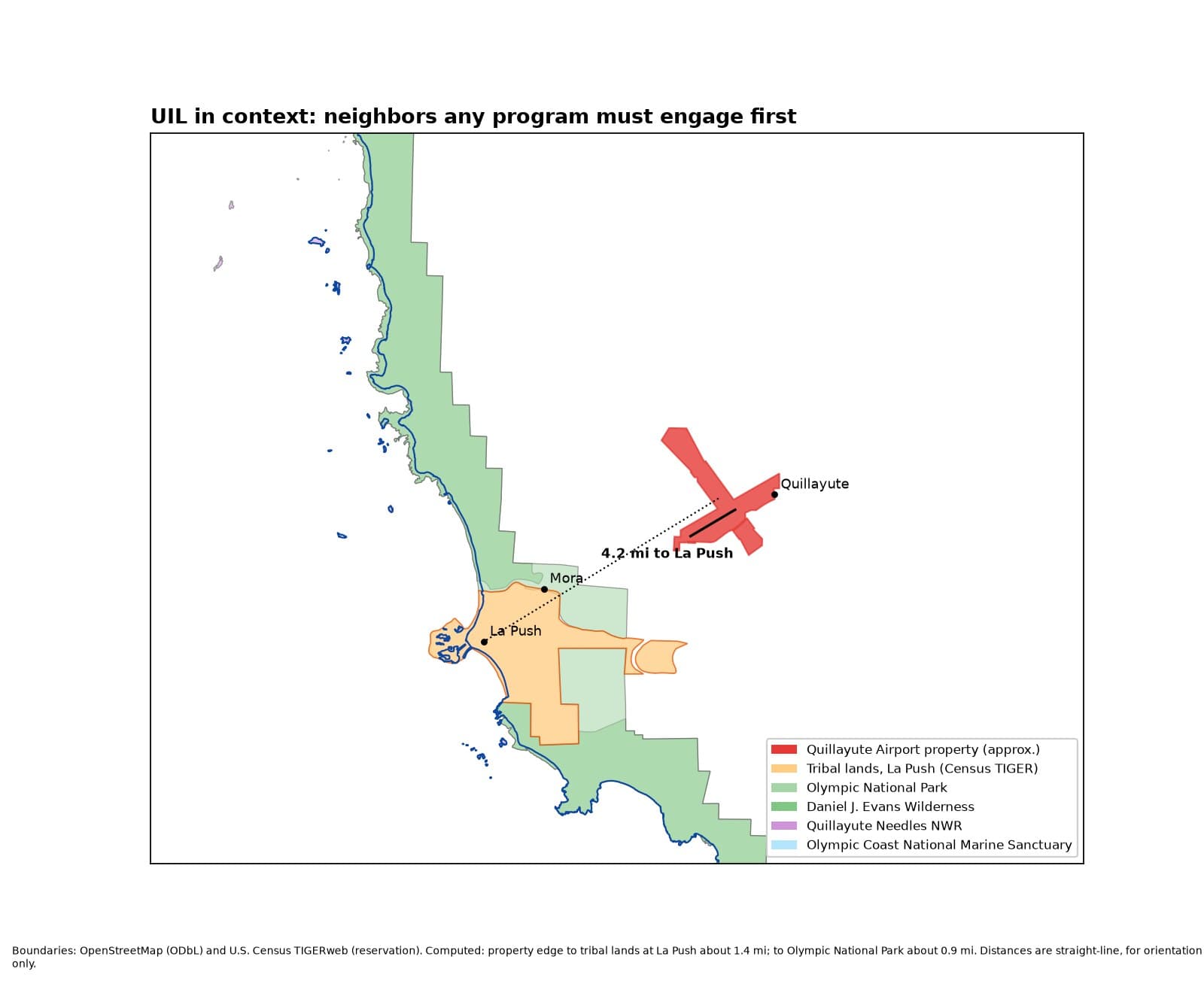
Tribal lands at La Push lie about four miles from the airport. Olympic National Park is closer still, and the Olympic Coast National Marine Sanctuary lies just offshore. Any honest plan starts with those neighbors, not with rockets.
George grew up in the Elwha Valley and has worked the land across the Peninsula. He believes the same rule applies here: go slowly, listen first, and build nothing that the people closest to it do not want.
Port Angeles As A True Port City
George believes Port Angeles is one of the finest natural ports anywhere. State and federal agencies put it more carefully: they describe Port Angeles Harbor as the largest natural deep-water harbor on the U.S. West Coast, with depths over 90 feet near its eastern end, sheltered by Ediz Hook. Source: Washington Department of Ecology, https://apps.ecology.wa.gov/cleanupsearch/document/99587
Two old mill sites frame the harbor:
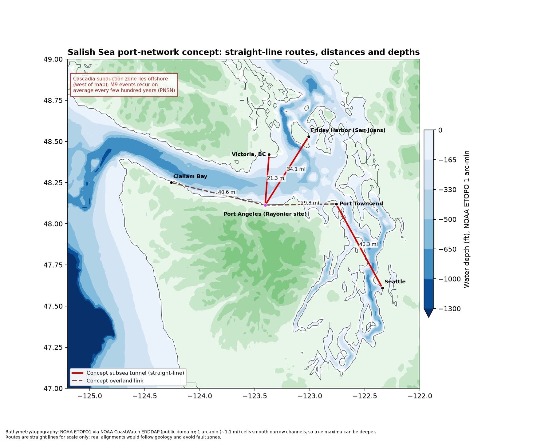
- The former Rayonier mill on the east waterfront, which George calls the "Rainier site." It is under a state cleanup consent decree signed in June 2026, now in the design phase. George sees it, someday, as the hub for concept tunnels fanning out first to Starbase Quillayute and on to Forks, and to Victoria, BC, Port Townsend, Edmonds and downtown Seattle. These are concept destinations, not engineered alignments. In his concept, the old creosote dock and jetty would come out under the state cleanup and be replaced by a new cruise pier on clean piles in the same spot, with a public promenade on top in the spirit of City Pier downtown, extending the waterfront walk. Any acquisition would help fund and speed up the cleanup and habitat mitigation, under the state's cleanup oversight. Concept only; no deal or agreement exists.
- The former McKinley Paper mill at the base of Ediz Hook, closed in 2024, with a sale to a new owner announced in 2026. It already has waterfront power and utility connections.
Ediz Hook as a seawall people love
Ediz Hook already protects the harbor, and the Army Corps of Engineers keeps it armored with stone and fresh cobble. The state's tsunami models show a Cascadia earthquake could send water over the entire Hook about an hour after the shaking.
George's idea is to raise the Hook into an engineered seawall that doubles as a promenade for walking and biking, built low and green enough that you can still see the water. The model is the Dutch seaside dike you can stroll on, not the tall concrete walls Japan built after 2011 that cut towns off from the sea.
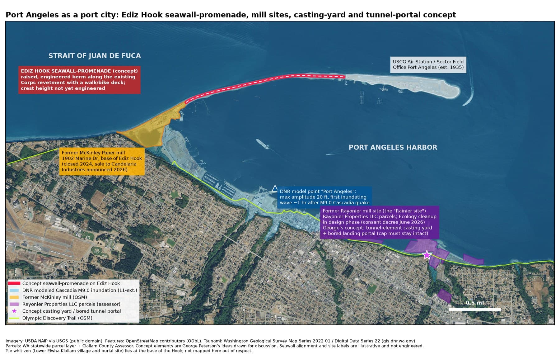
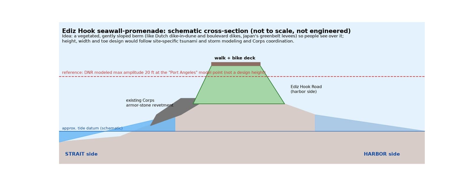
The base of Ediz Hook is also Tse-whit-zen, a Lower Elwha Klallam village and burial ground. Nothing gets built there without the Tribe.
Tunnels Under the Salish Sea
Undersea tunnels are real and getting deeper. There are two main ways to build them, and the difference matters here.
Immersed tubes are giant concrete or steel sections built in a dry casting basin, floated out, towed to the site and sunk into a trench dredged in the seabed, then joined underwater. Denmark's Øresund tunnel, the Fehmarnbelt tunnel now under way between Denmark and Germany, Korea's Busan-Geoje link, the Hong Kong-Zhuhai-Macao crossing and BART's Transbay Tube under San Francisco Bay were all built this way.
Bored tunnels are dug through rock or soil beneath the seabed by a tunnel boring machine or by drilling and blasting, like the Channel Tunnel or Norway's Rogfast, which will reach about 1,290 feet below sea level.
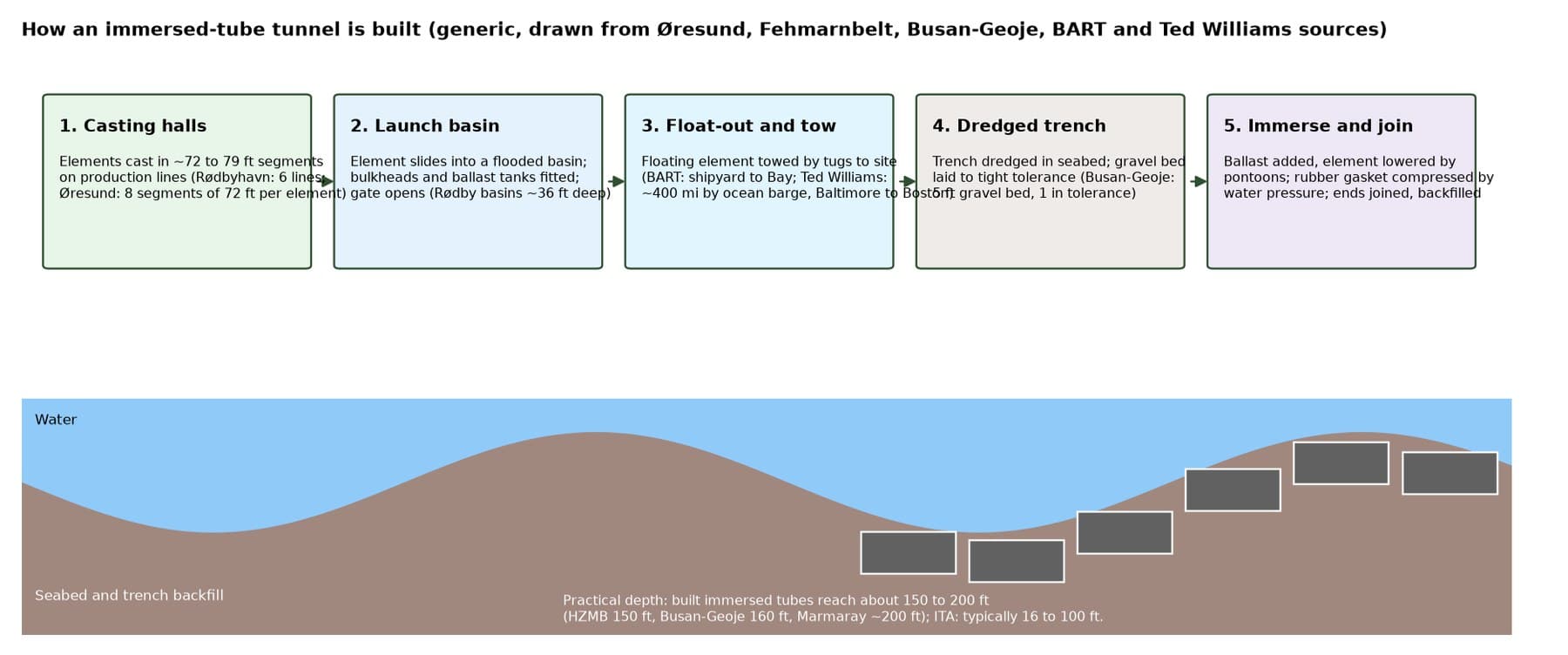
George believes most Salish Sea tunnels should be immersed tubes, with boring only at the landings and portals, done by a specialist tunneling contractor. No contractor has been chosen or contacted.
Here is the honest picture. The deepest immersed tubes ever built sit in about 150 to 200 feet of water, so George sees them fitting the harbor approaches and landings, and perhaps Admiralty Inlet near Port Townsend (about 210 feet at its sill), the sensible first study.
The crossing to Victoria is deeper, roughly 420 feet on a straight line, and George sees it the way he sees Mars: a frontier stretch goal worth exploring, because ambitious targets push engineering forward. There are two paths. One is a deep rock tunnel, like Norway's Rogfast, which is going to about 1,290 feet below sea level. The other is a submerged floating tunnel, a tube anchored at a set depth below the surface, which Norway has studied in detail for its E39 coastal highway. Neither has been built across water this deep in an earthquake zone like ours, and no floating tunnel has been built anywhere yet. That is what makes it a frontier, not a closed door.
The Salish Sea also sits in the Cascadia earthquake zone, crosses treaty fishing grounds and, toward Victoria, an international border.
A casting yard, and a hub for the world
George believes Port Angeles could build tunnel sections, not just receive them, and someday ship them around the Pacific. There is precedent for building elements far from the tunnel: the steel sections of Boston's Ted Williams Tunnel were made in Baltimore and carried about 400 miles by sea. We found no case of elements shipped across an ocean, and big projects usually build their own yard nearby. Washington has history here too, some of it painful: the state's graving yard for Hood Canal Bridge pontoons in Port Angeles was abandoned in 2004 when Tse-whit-zen was uncovered.
The old Rayonier mill site is a hard fit for a casting basin. The state's cleanup plan there caps contamination in place, and a casting basin means digging a large hole by the shore. Any yard would have to work around that cap, with the Department of Ecology's approval, and with the Lower Elwha Klallam Tribe at the table.
Tunnel sections that hold data centers
George believes some tunnel sections could house data centers cooled by the sea, with dry walk-in access. Underwater data centers are real: Microsoft's Project Natick ran 864 servers off Scotland from 2018 to 2020 with one-eighth the failure rate of a land-based group, though Microsoft has since ended the program, and China's HiCloud now runs commercial subsea modules off Hainan and Shanghai. Norway cools data centers in mountain halls with cold fjord water.
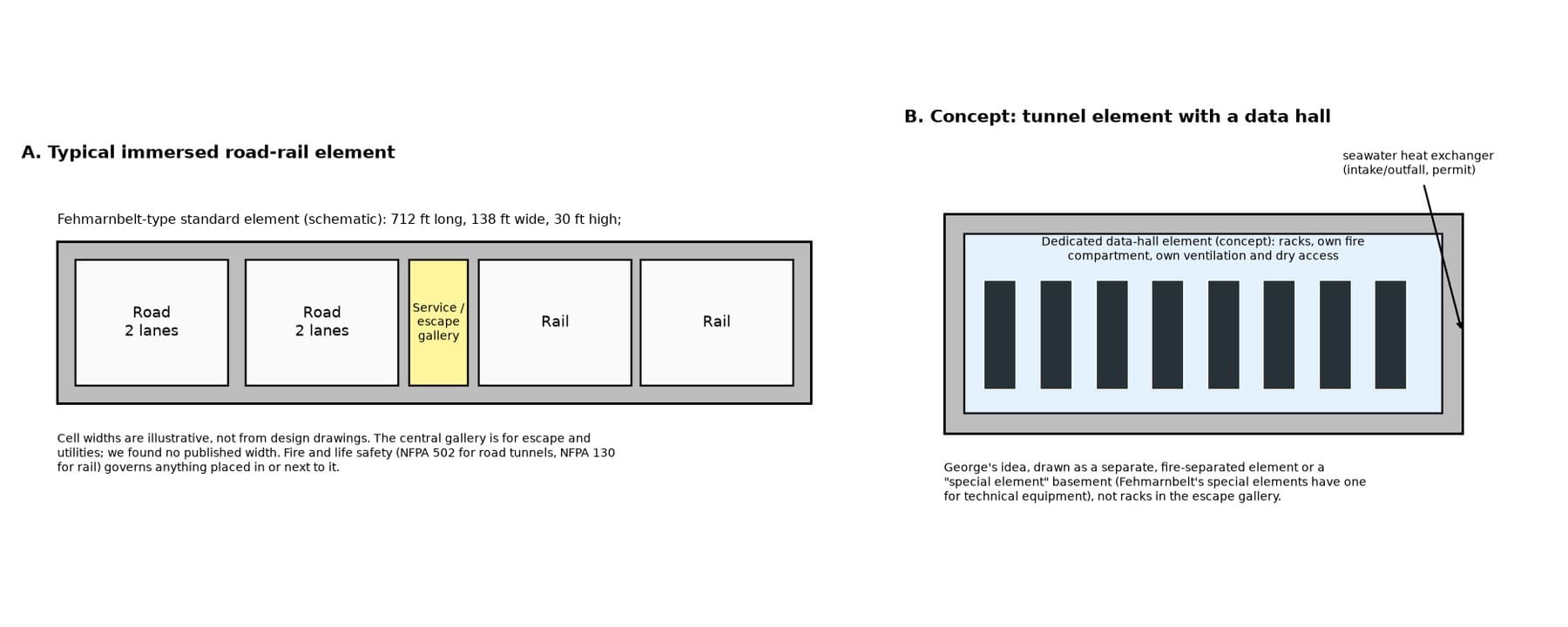
Honest picture: racks will not fit in a tunnel's escape gallery, which fire codes keep clear for people. A separate, fire-sealed section or a data center at the tunnel portal is more realistic, and releasing heat into the sea would need a state water-quality permit and care for salmon and treaty fisheries.
How Ownership Could Work
Third Harvest is independent. We do not pick parties, and we are conservative about money: we would rather prove a small thing than promise a big one. George believes tokenized real-world assets can let a town, a tribe, a timber owner and an aerospace partner each hold a clear, recorded share of the same project, without anyone having to trust a backroom deal.
- The Harvest Oracle would value the forest, the land and the infrastructure on the same public measuring stick, so everyone sees the same numbers.
- Sustainable forestry stays on the land. The airport's working forest is part of the plan, not in the way of it.
- First Nations partnership comes before any token, on terms the tribes set.
Nothing here is an offer of securities, and no token exists for this project.
What We Don't Know Yet
- Whether the City of Forks, the FAA or neighboring tribes would welcome any of this. Nobody has been asked yet.
- Whether any aerospace company would take an interest. Outreach to aerospace teams is planned, not started, and nothing has been sent. No company named on this page is involved.
- How any tunnel would be engineered, and who would build it. The deep Strait crossings would be a first of their kind.
- Whether fiber reaches the airport, and how a ground station would coordinate with Navy training.
- What a seawall on Ediz Hook would need to look like, and what the Corps and the Lower Elwha Klallam Tribe would think of it.
We will post what we learn, including the parts that do not go our way.