
Vision · Concept
Native gateway roundabouts
West of Port Angeles, US 101 carries the traffic of the western Peninsula: freight from the west end, visitors to Lake Crescent and the Elwha, and people from Joyce and Clallam Bay by way of SR 112. Three intersections on that stretch are where the rural highway meets the town.
Third Harvest's concept rebuilds each one as a modern single-lane roundabout sized for the longest legal trucks, with a central island planted as a low mound of Olympic foothill forest floor. Together they would make a gateway that says where you have arrived.
Where this fits in the thousand years: Near-term step. Research now on road fixes that could come early. See the timeline. What happens between now and then is on us.
Three intersections
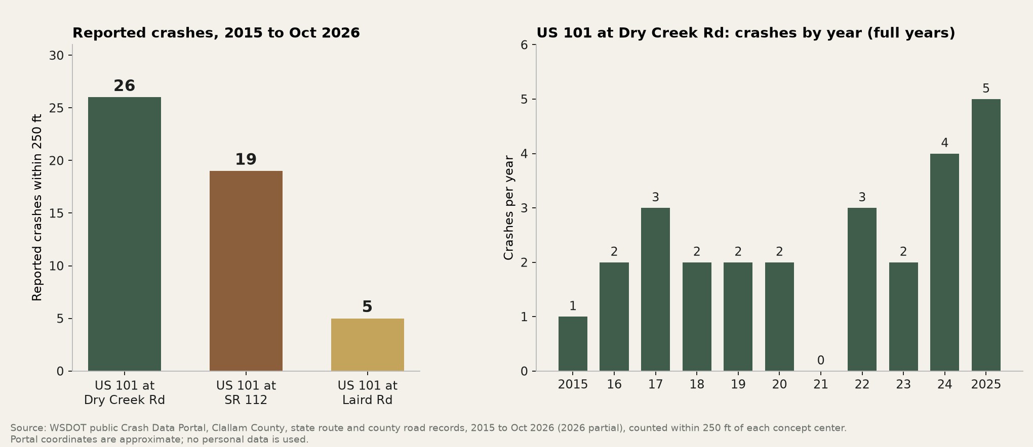
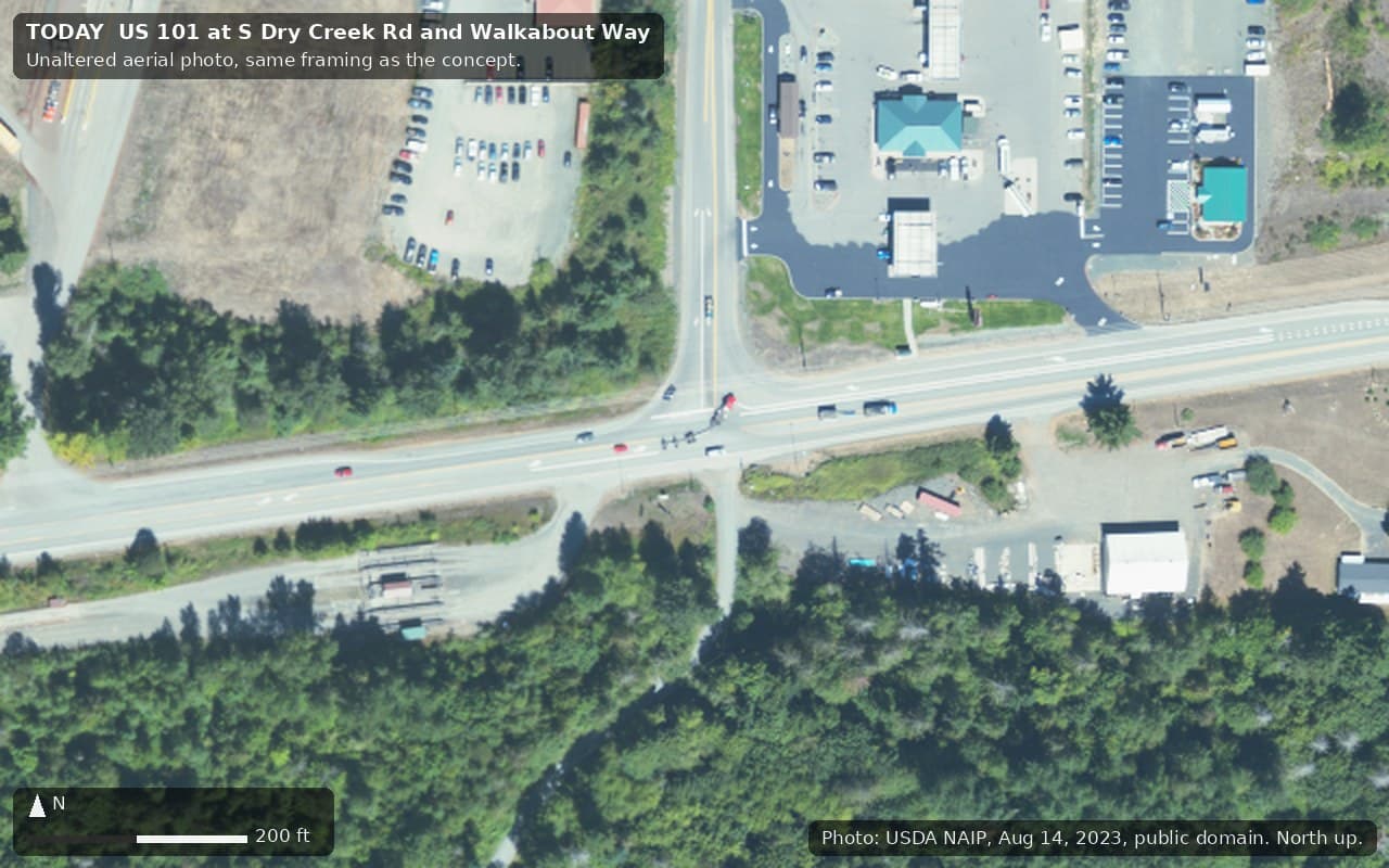
- US 101 at S Dry Creek Rd and Walkabout Way, the corner with the gas station beside Lower Elwha Klallam Tribal land. It carries about 11,000 vehicles a day and had 26 reported crashes within 250 feet from 2015 to October 2026, 23 of them coded as intersection-related, with 4 in 2024 and 5 in 2025.[6, 7, 17]
- US 101 at Laird Rd and Straitland Rd, Laird's Corner. The two side streets are offset about 160 feet apart on a 50 mph freight route carrying 9,500 to 11,000 vehicles a day, with several business driveways. It had 5 reported crashes, all with no apparent injury.[6, 7, 8]
- US 101 at SR 112, a skewed, high-speed wye with a slip ramp. SR 112 carries about 5,200 vehicles a day, about 9% of them trucks, and its approach is posted at 55 mph. It had 19 reported crashes within 250 feet, including one suspected serious injury and 3 involving heavy trucks.[6, 7, 8]
All three sit on state freight routes.[9]
Why roundabouts
WSDOT's own rules already point here. Its Intersection Control Evaluation requires a roundabout to be considered whenever an intersection is improved,[2] and its roundabout chapter sets the design rules for them.[1] A roundabout slows traffic at the intersection and removes the high-speed crossing movements that cause the worst crashes, while keeping freight moving.
WSDOT is already planning two-lane roundabouts on US 101 east of Port Angeles, at Taylor Cutoff Road and Mill Road, with bids expected in early 2027 and construction in summer 2027.[10]
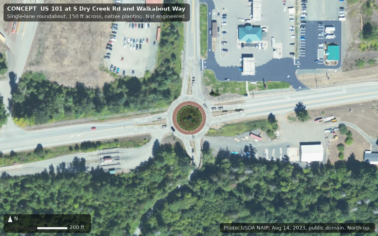
ConceptAt each site, a single-lane roundabout about 150 feet across, with an 18 foot circulating lane, a 13 foot mountable truck apron sized for the longest legal semi-trucks, and a raised splitter island on every approach. At Laird Road the circle pulls both offset side streets into one intersection. At SR 112 it replaces the skewed wye and slip ramp with a right-angle entry. Lane count and size would be set by WSDOT's capacity analysis.
A piece of the foothills in each island
ConceptEach central island becomes a low, mounded piece of Olympic foothill forest floor: sword fern, salal, rushes and vine maple around a weeping western hemlock, a dwarf weeping form of the Peninsula's own native tree.[12, 13] On the approaches, full-size western hemlocks with vine maple, salal and sword fern form gateway groves, set back outside the clear zone and sight lines.
Safety sets the rules. On approaches of 45 mph and above, or on freight corridors, WSDOT's Roadside Policy Manual allows only trees or large shrubs "with mature trunks less than 4 inches in diameter" in central islands, says "do not use large boulders or fixed objects," and calls for the island to be mounded and planted to block headlight glare and views across the circle.[4] WSDOT's roadside safety chapter treats trees 4 inches or more in diameter as fixed objects.[3] The concept follows those rules: the big trees stand in the gateway groves, the island holds plants a vehicle can ride over or through, and there is no rock of any size, in the islands or in the groves.
Lighting the way in
WSDOT's roundabout chapter says to "light the roundabout from the outside in toward the center," and notes that "ground-level lighting within the central island that shines upward toward objects in the central island can also improve their visibility."[1]
ConceptStreet lights at each entry and splitter island, pointed down. In the island, two or three low, shielded, warm uplights set close to the hemlock and aimed up into its crown, away from every approach, so drivers see the lit tree, not the lamps. Light poles in the clear zone would be on breakaway bases.[3]
Grown here, cared for here
WSDOT keeps formal roundabout landscapes only where a local partner agrees to maintain them. Without one, its practice is to pave the interior or cover it with rock.[5]
ConceptPlants grown on the Peninsula from local stock, and a maintenance agreement with community, Tribal or County partners. Local native propagation already happens here, at the Clallam Conservation District's native plant sale and Olympic National Park's Matt Albright Native Plant Center.[14, 15]
What would have to be true
What would have to be true
- The Lower Elwha Klallam Tribe. The Dry Creek corner borders Lower Elwha Klallam Tribal land, and the whole corridor lies in Klallam homelands.[17] Any design, plant choice or story told by these gateways should be shaped with the Tribe, through WSDOT's government-to-government consultation.[11]
- WSDOT. US 101 and SR 112 are state highways. Each site needs an Intersection Control Evaluation by a licensed engineer, right-of-way plans and turning-movement counts.[2]
- A maintenance partner for the planted islands and groves.[5]
- Funding. No cost has been estimated.
Nobody has been contacted, and nothing here implies the involvement or endorsement of any agency, tribe or company.
Sources
Free public sources, checked October 2026. Numbers in brackets in the text point here.
- 1.WSDOT Design Manual M 22-01.23, Chapter 1320 Roundabouts
- 2.WSDOT Design Manual M 22-01.23, Chapter 1300 Intersection Control Type
- 3.WSDOT Design Manual M 22-01.23, Chapter 1600 Roadside Safety
- 4.WSDOT Roadside Policy Manual M 3110.04, Chapter 6 Roundabouts
- 5.WSDOT Maintenance Manual M 51-01, Chapter 6 Roadside Management
- 6.WSDOT Crash Data Portal (public), Clallam County, 2015 to Oct 2026
- 7.WSDOT GeoData, Traffic Data (2025 annual average daily traffic and truck share)
- 8.WSDOT GeoData, Roadway Characteristic Data (posted speeds)
- 9.WSDOT GeoData, Freight and Goods Transportation System
- 10.Radio Pacific, "WSDOT Lays Out Timeline for 101 Roundabouts and Spring Hood Canal Bridge Closures," Dec 10, 2025
- 11.WSDOT, Executive Order E 1025.01, Tribal Consultation
- 12.Oregon State University Landscape Plants, Tsuga heterophylla 'Thorsen's Weeping'
- 13.Washington Native Plant Society, Native Plant Directory
- 14.Clallam Conservation District, Native Plant Sale
- 15.National Park Service, Matt Albright Native Plant Center, Olympic National Park
- 16.USDA NAIP imagery, 2023 (public domain)
- 17.Clallam County GIS (parcels and tribal lands)
Related
Concept only. Nothing on this page has been approved by, or agreed with, any agency, tribe or company. Nobody was contacted to prepare it.