
Vision · Concept
Downtown tunnels
US 101 runs through the middle of downtown Port Angeles as a one-way pair, westbound on Front Street and eastbound on First. Semi-trucks, ferry traffic, Park visitors and people on foot all share the same few blocks. Third Harvest's concept puts the freight and through traffic underground in two tunnels, one under each street, joined to the existing SR 117 truck route west of downtown, so trucks never surface downtown.
Above them, Front Street and the core become a green corridor. This page lays out the problem in the City's own words, the concept on real ground, the soft soils it would meet, and the state decisions it would need.
Where this fits in the thousand years: Later step. Front Street and First Street freight tunnels work toward the century-one goal of a first tunnel segment open at Port Angeles. See the timeline. What happens between now and then is on us.
- About 1,400
- Freight vehicles a day the City wants off the historic downtown street grid[1]
- About 34,000
- Vehicles a day on US 101 just east of downtown, 2025[4]
- About 1.6 miles
- Length of each concept tunnel, Front Street and First Street
- 4%
- Steepest grade in the concept, the preferred limit for road tunnels
The problem the City already names
In its April 2026 request for engineering firms, the City wrote that "freight traffic to and from the east, where the Port serves many markets, is forced through downtown Port Angeles."[1] Its planned fix to the SR 117 truck route interchange with US 101, project TR1799, aims at "removing approximately 1,400 freight vehicles per day from the historic downtown street grid."[1] The City's capital plan carries TR1799 at about $13.7 million.[3]
The adopted 2025 Comprehensive Plan says that "currently, US 101 and SR 117 consist of the City's truck route."[2] WSDOT counted about 34,000 vehicles a day on US 101 just east of the downtown pair in 2025, about 4% of them trucks, and about 7,400 a day on SR 117, about 19% trucks.[4]
The question is old. When the City Council dropped Lauridsen Boulevard as a cross-town truck route in 2016, the Peninsula Daily News noted that "trucks still make their way down Front Street," and a downtown business owner told the paper that heavy truck traffic downtown "is not only dangerous, it's not clean."[5]
On safety, the City's 2024 Local Road Safety Plan says pedestrian and bicycle crashes in Port Angeles "are primarily clustered on the US 101 corridor, 1st Street and Front Street." From 2018 to 2022, 4 of the City's 13 serious-injury crashes involved a pedestrian.[6]
Two tunnels, one continuous freight path
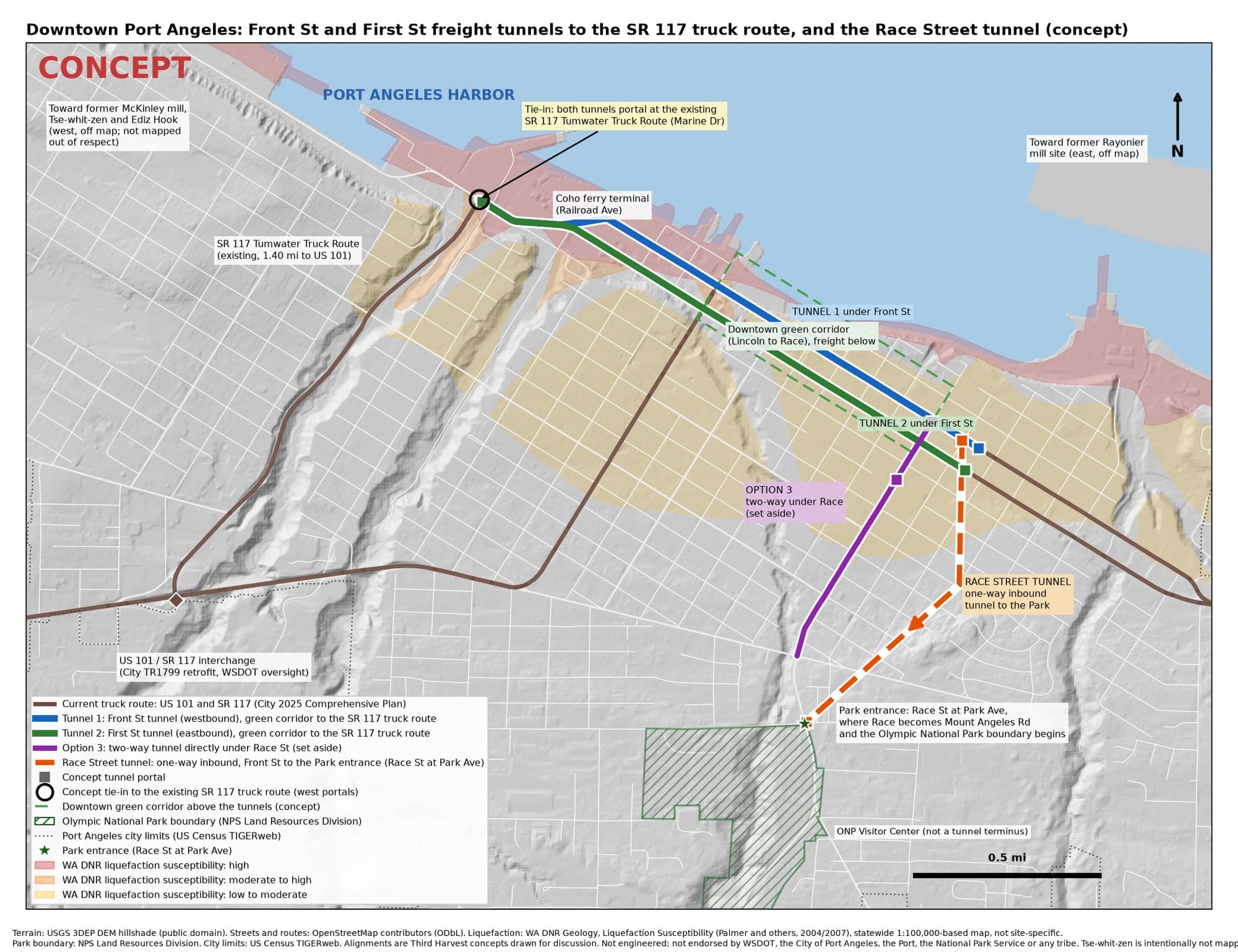
ConceptTwo tunnels sized for semi-trucks, with 16.5 feet of clearance, mirror today's one-way pair. The Front Street tunnel carries westbound traffic and the First Street tunnel eastbound. Both run under the downtown green corridor from just east of Race Street to Lincoln Street, then side by side under Marine Drive along the western waterfront, and come up at the existing SR 117 Tumwater Truck Route, which already climbs to US 101 west of town. Nothing runs under Lincoln Street, which stays a surface street.
- Front Street tunnel: about 1.57 miles at a 4% maximum grade, about 4,800 feet of it bored. The roadway is up to about 80 feet below ground and dips to about 55 feet below sea level under the waterfront.
- First Street tunnel: about 1.54 miles at 4%, about 4,700 feet bored, dipping to about 50 feet below sea level.
- Portals: the east portals sit just east of Race Street, about 360 feet east on Front and about 430 feet east on First. The west portals sit side by side on Marine Drive about 410 feet east of the SR 117 junction.
- One continuous path: freight and through traffic stay underground for the whole downtown core. At the west end, trucks continue on Marine Drive to the Port or climb SR 117 to US 101.
Figures are from a rough model on USGS elevation data along OpenStreetMap street centerlines.[17] They are concept numbers, not a design.
What the town gets back
With freight and through traffic below, Front Street can become a linear park: trees and rain gardens, a walk and bike path, lawn and room for events, and one shared lane for local trips, transit, deliveries and emergency vehicles. First Street becomes a calmer local street with street trees. The waterfront edge along Railroad Avenue joins up with it.
Front Street today (schematic)
Front Street with freight below (concept)
The Coho ferry terminal sits on Railroad Avenue.[11] The Front Street tunnel passes that block too deep for a short ramp, so ferry vehicles would use the surface streets, which stay open. Whether that works for ferry trucks and queues is an open question for the ferry operator and the City.
Fixing the ground while we dig
Downtown Port Angeles stands on made ground. In 1914 the town sluiced a hillside into retaining walls and raised "sections of downtown streets up to 15 feet," moving "almost 400,000 cubic yards of earth", and in the 1920s it filled the mud flats from Front Street out to Railroad Avenue.[7] State geologic mapping shows artificial fill along the waterfront.[10]
Washington DNR rates the waterfront strip high, or moderate to high, for liquefaction in a large earthquake.[8] A May 2026 geotechnical report for 801 Marine Drive found saturated dredge fill with "a high potential for soil liquefaction during a large-scale seismic event."[9] Port Angeles lies above the Cascadia Subduction Zone.[16]
ConceptThe shallow tunnel sections and portals would sit in that fill, so building them means improving the ground block by block along the line. That is ground work the waterfront may need anyway. How much it would help neighboring buildings is a question for geotechnical engineers and borings, not a promise.
West of Lincoln Street both tunnels run below sea level in saturated fill with tidal groundwater, for well over half a mile. That is the hardest part of the concept: watertight linings, resistance to uplift, and dewatering or ground freezing at the portals. The line also passes the City's combined sewer overflow works and pump station on Marine Drive, which any design would have to work around.
The state decisions it would need
- WSDOT owns the highway. US 101 and SR 117 are state routes. TR1799 is already a WSDOT-oversight project,[1] and any tunnel that carries US 101 and ties into SR 117 would be a WSDOT project or need WSDOT approval at every step.
- The route through town would change. Moving US 101 through traffic onto SR 117 changes the highway's route through Port Angeles, which is a state decision.
- It overlaps TR1799. Today the SR 117 interchange with US 101 "only allows movement to and from the west."[1] The tunnels use exactly those movements, and the City's planned two-way interchange serves a related goal, so the two would be planned together.
- Marine Drive at SR 117 would have to be rebuilt to handle tunnel traffic, SR 117 traffic and local trips. That junction has not been designed.
What would have to be true
What would have to be true
- The Lower Elwha Klallam Tribe first. Its ancestral village and burial ground, Tse-whit-zen, lies at the base of Ediz Hook, where the state stopped a construction project in December 2004.[14, 15] The west portals are on the western waterfront. Any digging there starts with government-to-government consultation, before design.
- Partners. WSDOT, the City, the Port and the ferry operator.
- Engineering and review. Full engineering to road tunnel practice, including ventilation, fire and hazardous cargo rules,[12] geotechnical borings, NEPA and SEPA environmental review, and cultural resources review under Section 106.
- Money. For scale only, Seattle's SR 99 bored tunnel, including access, cost about $2.05 billion for a bore of about 1.76 miles.[13] Two downtown tunnels of about 1.5 miles each would be a multi-billion-dollar public project.
The Race Street tunnel to the Park shares the Front Street portal area. See the Race Street Olympic National Park Project.
Nobody has been contacted, and nothing here implies the involvement or endorsement of any agency, tribe or company.
Sources
Free public sources, checked October 2026. Numbers in brackets in the text point here.
- 1.City of Port Angeles, RFQ TR1799, SR 117 Truck Route at US 101 Interchange Improvements, Apr 10, 2026
- 2.City of Port Angeles, 2025 Comprehensive Plan, Volume II Appendices (Appendix D, Transportation)
- 3.City of Port Angeles, Capital Facilities Plan and Transportation Improvement Plan 2025 to 2030
- 4.WSDOT, Traffic Counts (2025 annual average daily traffic and truck share)
- 5.Peninsula Daily News, "Port Angeles City Council cuts Lauridsen Boulevard as cross-town truck route," Jun 24, 2016
- 6.City of Port Angeles, Local Road Safety Plan, updated May 2024
- 7.Peninsula Daily News, "Port Angeles downtown taken to new level in 1914 by fill project," Jun 20, 2014
- 8.Washington DNR Geology, Ground Response (liquefaction susceptibility and site class)
- 9.Geotechnical Engineering Report, 801 Marine Drive, May 28, 2026 (City of Port Angeles permit record)
- 10.Washington DNR, Open File Report 2003-6, Geologic Map of the Port Angeles 1:100,000 Quadrangle
- 11.Black Ball Ferry Line, About Us (M.V. Coho and the Port Angeles terminal)
- 12.FHWA, Technical Manual for Design and Construction of Road Tunnels, Civil Elements
- 13.FHWA Center for Innovative Finance, Alaskan Way Viaduct (SR 99) project profile
- 14.Lower Elwha Klallam Tribe, Tse-whit-zen
- 15.HistoryLink Essay 7344, the state halts the Port Angeles graving dock project, Dec 2004
- 16.Pacific Northwest Seismic Network, Cascadia Subduction Zone
- 17.USGS 3D Elevation Program
Related
Concept only. Nothing on this page has been approved by, or agreed with, any agency, tribe or company. Nobody was contacted to prepare it.