
Vision · Concept
Rayonier hub
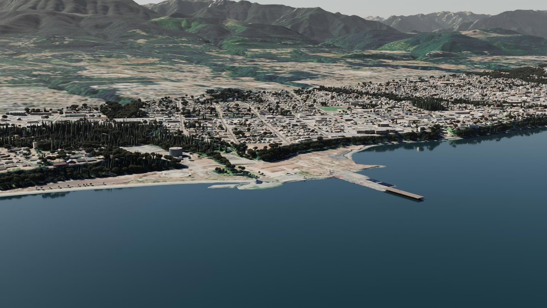
The former Rayonier pulp mill is the largest idle stretch of the Port Angeles waterfront: about 80 acres on the Strait, with Ennis Creek running through it.[4] Third Harvest sees it as the front door of a port city: a new cruise pier on clean piles where the old creosote dock stands, a public promenade on top, and the main hub where the concept tunnels begin.
The state cleanup comes first and stays whole. This page sets out what the cleanup requires, how an owner could help speed it, what the hub would look like, and where the tunnels would go from it.
Where this fits in the thousand years: Later step. The hub where the West End, Olympia and Seattle lines meet, beside a new cruise pier on clean piles, built toward the century-one goal. See the timeline. What happens between now and then is on us.
The site today
Rayonier ran a pulp mill here from 1930 to 1997.[1] Interim actions removed more than 30,000 tons of contaminated soil, but contamination remains in soil, groundwater and sediment.[1] Ecology signed the consent decree on June 23, 2026, and the cleanup is now in its "design the cleanup" step.[1, 8] Ecology expects engineering design to take about five years and the overall restoration timeframe to be up to 10 years.[1, 3]
The dock and jetty are part of the problem. Ecology's final plan says "removal of the dock is a necessary element of the remedy for the marine portion of the Study Area." The dock stands on about 4,000 creosote pilings, and the jetty, about 700 feet long, is creosote wood cribbing that is an ongoing source of contamination.[4] Ecology also says "the dock and jetty must be removed before sediment remediation begins."[7]
Ecology is clear that the future of the land is not its call: "Ecology is not involved in selecting or implementing future land uses; these decisions rest with the property owner and local government."[3]
The hub
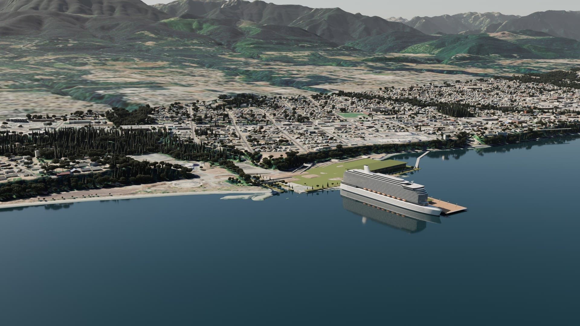
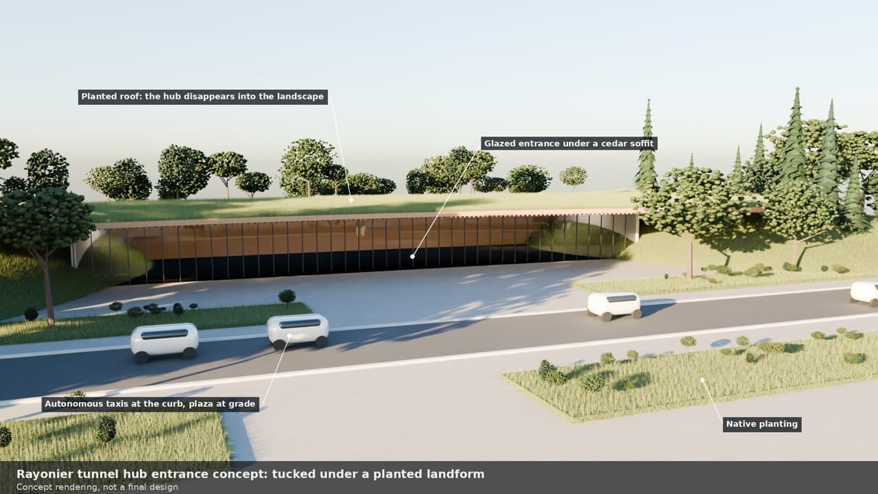
ConceptThe old dock and jetty come out under the state cleanup. After or alongside it, a new cruise pier is built on clean piles in the same spot, with a public promenade on top in the spirit of City Pier downtown,[11] extending the waterfront walk that already runs along the harbor.[12] Beside it, a tunnel portal tucked under a planted landform, a plaza at grade, and autonomous taxis waiting at the curb. Passengers step off the ships and into the city or the tunnels with no climb and no shuttle bus.
The shoreline is restored with native planting, and the plan keeps room for restoring Ennis Creek and its estuary, which the cleanup plan keeps open.[4] Under state law, any reuse must not interfere with the remedy, so nothing here would delay dock removal, disturb the soil cap or block Ennis Creek restoration.[5]
How an owner could speed the cleanup
Washington law already has a tool for a buyer who brings new money and speed to a cleanup site. A prospective purchaser settlement is allowed where it "will yield substantial new resources to facilitate cleanup" and "will expedite remedial action," and where the reuse is not likely to interfere with the remedy.[5] The existing liable parties stay bound by the decree after any sale.[8]
ConceptAny acquisition would add resources to the state-supervised cleanup, not replace or skip any part of it: money, contractor capacity or scheduling help for dock removal, sediment work and shoreline recontouring, and help with Ennis Creek and estuary restoration if the trustees and the liable parties agree.
The public has asked for more. Ecology received 386 comments from 359 commenters in 2025, and reports that roughly 89% of commenters asked for all contaminated material to be removed. The selected soil remedy consolidates and caps soil on site, at a 2019 estimated cost of $10 million against $37 million for full removal.[6, 7] The City asked for a full site cleanup.[10]
A public attempt to buy the site has been made before. In 2008 the City and the Port formed the Port Angeles Harbor Works Development Authority to acquire the property; after due diligence paid for by a state grant, they decided not to buy it.[1]
Ennis Creek and the Lower Elwha Klallam Tribe
The Klallam village of I'e'nis sat on the east bank of Ennis Creek, and parts of the property have "a moderate to high probability" of cultural resources.[4] Under agreements from 1999 and 2000, the Lower Elwha Klallam Tribe holds a right of concurrence in major cleanup decisions at the site, and its June 2026 letter tied its concurrence to how in-water structures are handled.[9]
For Third Harvest, the Tribe is a partner to invite, with Ennis Creek restoration in mind, on the Tribe's own terms. It has not been approached and is not involved in this concept.
Where the tunnels go
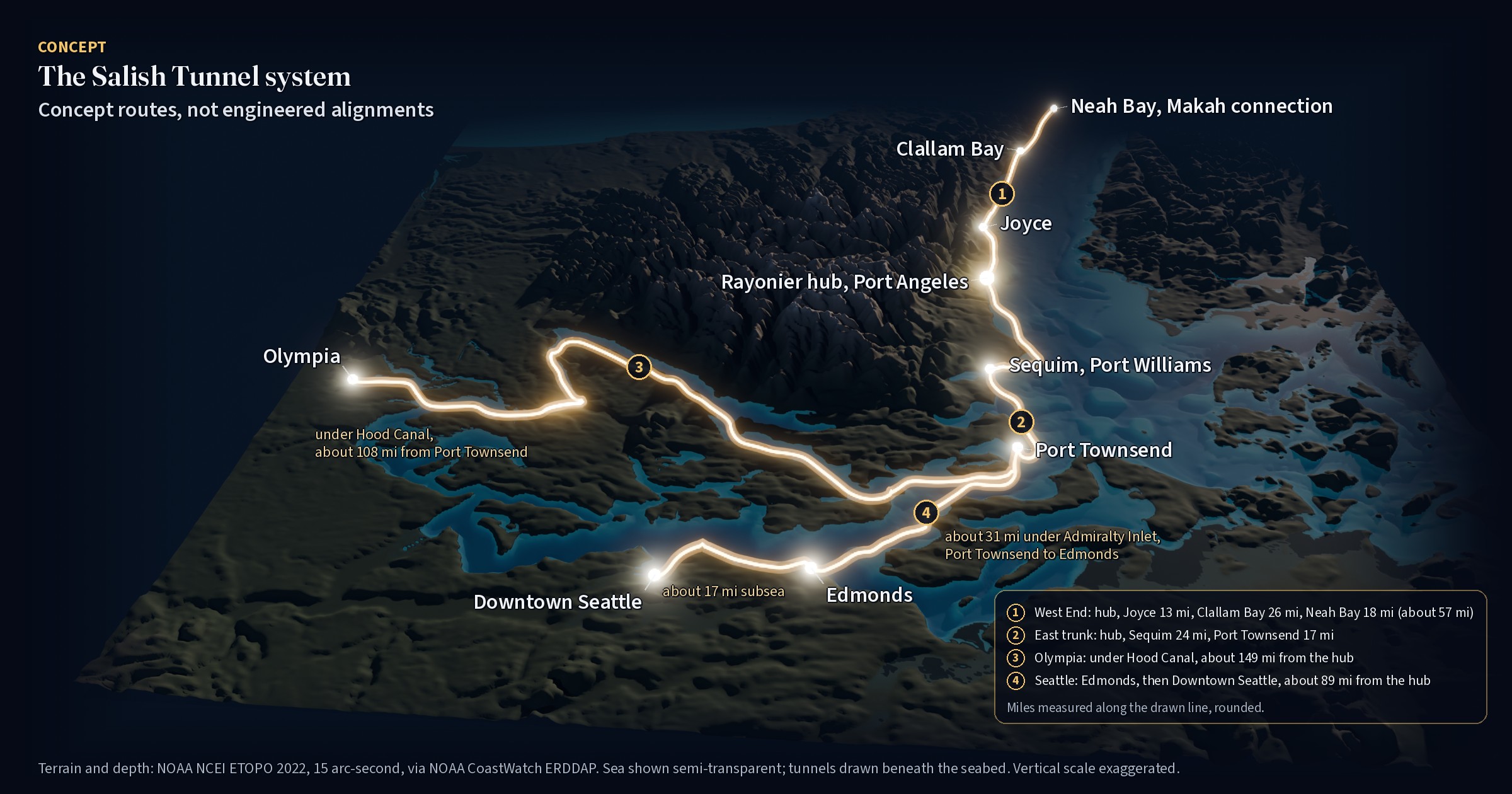
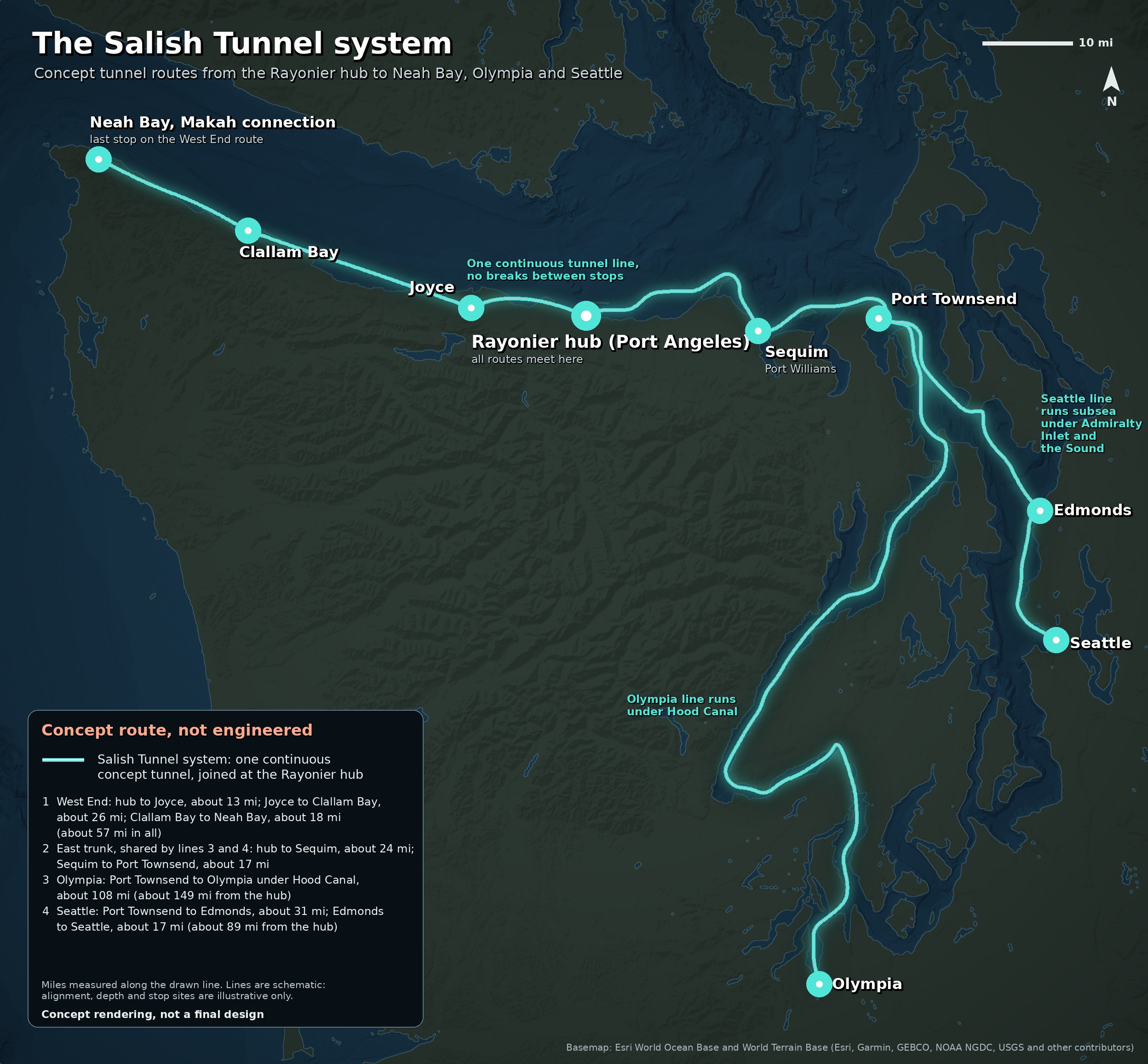
The hub is where the Salish Tunnel system, the concept tunnel network, starts. The West End line runs west to Joyce and Clallam Bay and ends at Neah Bay, Makah connection, about 57 mi in all. East, a shared trunk runs to Sequim at Port Williams and on to Port Townsend. From there the Olympia line runs under Hood Canal to Olympia, about 149 mi from the hub, and the Seattle line runs subsea through Admiralty Inlet to Edmonds and under the Sound to downtown Seattle, about 89 mi from the hub. All three are drawn as one continuous tunnel joined at the hub, with no breaks between stops. None of these routes has been studied, engineered or approved.
Concept · The Salish Tunnel system
One hub. Three lines. No breaks.
The Salish Tunnel system starts at the Rayonier hub in Port Angeles. From there, one continuous concept tunnel would run west along the Strait to Joyce and Clallam Bay, ending at Neah Bay, Makah connection, about 57 mi in all. East, a shared trunk runs to Sequim at Port Williams and on to Port Townsend, about 42 mi. From there the Olympia line runs under Hood Canal to Olympia, about 149 mi from the hub, and the Seattle line runs subsea through Admiralty Inlet to Edmonds and under the Sound to downtown Seattle, about 89 mi from the hub. No breaks between stops.
Stops on the Salish Tunnel system
- 1
Rayonier hub (Port Angeles)
All routes meet here. The West End line runs west; the east trunk runs to Sequim and Port Townsend, where the Olympia and Seattle lines split.
- 2
Joyce
West End line. About 13 mi from the hub.
- 3
Clallam Bay
West End line. About 26 mi past Joyce.
- 4
Neah Bay, Makah connection
Last stop on the West End line. About 18 mi past Clallam Bay, about 57 mi from the hub.
- 5
Sequim, Port Williams
East trunk. About 24 mi from the hub, at Port Williams Beach.
- 6
Port Townsend
East trunk. About 17 mi past Sequim. The Olympia and Seattle lines split here.
- 7
Olympia
Olympia line. About 108 mi past Port Townsend, running under Hood Canal; about 149 mi from the hub.
- 8
Edmonds
Seattle line. About 31 mi past Port Townsend, subsea through Admiralty Inlet.
- 9
Downtown Seattle
Seattle line. About 17 mi past Edmonds, subsea under the Sound; about 89 mi from the hub.
Where this fits in the thousand years
Tunnels are the kind of work that outlasts the people who start it. On the timeline this is a later step, built toward the century-one goal and sketched now so the hard questions get asked early. See the timeline.
What happens between now and then is on us.
The same map, with the route list, is on the Rayonier hub page.
Things a real study would face
- The West End line runs about 57 mi along the Strait through Joyce and Clallam Bay to Neah Bay, crossing rivers and salmon streams. Each stop would need a portal site, local agreement and its own environmental review.
- The Olympia line runs about 149 mi from the hub by way of Sequim and Port Townsend and passes under Hood Canal: deep water, Navy activity and treaty fishing areas.
- The Seattle line crosses under Admiralty Inlet and Puget Sound to Edmonds and downtown Seattle: deep water, busy shipping lanes, Navy activity, treaty fishing areas and overlap with state ferry routes.
- Every route crosses tribal usual-and-accustomed areas, so tribes would need to be at the table from the start.
The flat map, and what runs inside
The Salish Tunnel system: flat map
The Salish Tunnel system has three concept lines that meet at the Rayonier hub, drawn as one continuous tunnel with no breaks between stops. The Olympia and Seattle lines share the east trunk as far as Port Townsend:
- West End: Rayonier hub to Joyce (about 13 mi), then Clallam Bay (about 26 mi), ending at Neah Bay, Makah connection (about 18 mi), about 57 mi in all
- East trunk: Rayonier hub to Sequim at Port Williams (about 24 mi), then Port Townsend (about 17 mi)
- Olympia: Port Townsend to Olympia under Hood Canal (about 108 mi), about 149 mi from the hub
- Seattle: Port Townsend to Edmonds, subsea through Admiralty Inlet (about 31 mi), then under the Sound to downtown Seattle (about 17 mi), about 89 mi from the hub
Data centers in the tunnels
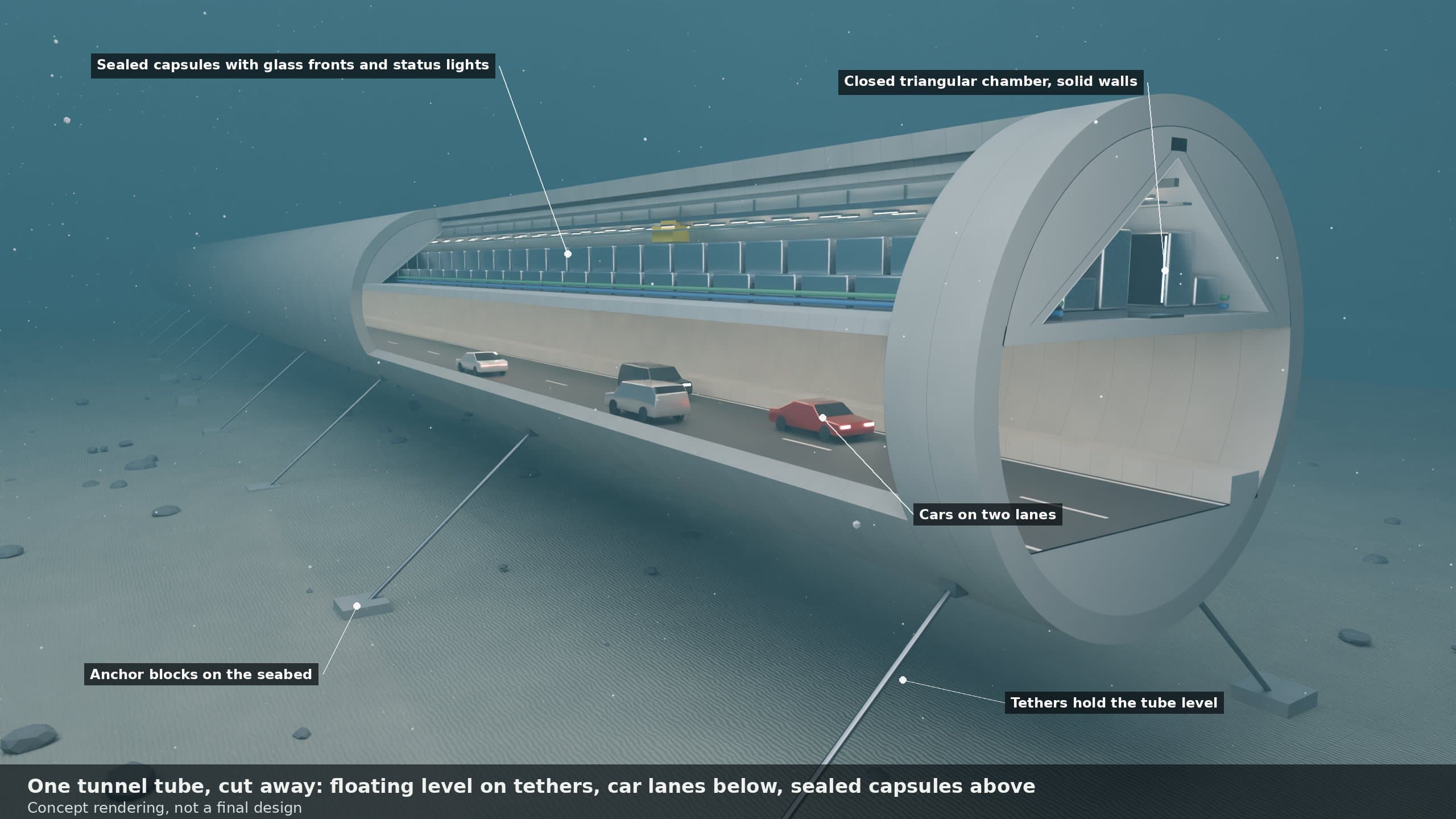
ConceptGeorge's concept: server racks housed in dedicated bored tunnel segments of the network, cooled by the sea.
- Underground data centers are already running in former mines and bunkers, from Norway's Lefdal Mine and Green Mountain to Iron Mountain's facility 220 feet below Pennsylvania.[Lefdal; Green Mountain; Iron Mountain]
- In China, Tencent's Qixing data center houses its servers inside tunnels dug into a mountain, showing that bored tunnel space can serve as a data hall.[Gui'an government, 2023]
- Norway's Green Mountain cools its servers with deep fjord water, and its regulator found in 2026 that the discharge has not degraded the fjord, while ordering further study of long-term effects.[Statsforvalteren permit 2026.0144.T]
- Google's Hamina data center reuses a former paper mill's seawater tunnel for cooling, a model for the old Rayonier mill site. Any Port Angeles version would need its own engineering, environmental and tribal review and a Washington Ecology discharge permit.[DCD 2011; WAC 173-201A]
Concept-level caveat: The racks would sit in dedicated tunnel segments, separate from the bores that carry traffic, with their own cooling, fire separation and access. We found no data center operating inside a road or rail tunnel today, so this is a new combination of proven building blocks. It would need its own engineering, environmental and tribal review and a Washington Ecology discharge permit.
What would have to be true
What would have to be true
- A willing seller. No public record shows that the owners want to sell.
- Liability protection. A buyer that takes title becomes an owner under the state cleanup law unless protected by a prospective purchaser settlement.[5]
- Court approval. Substantial changes to the decree need a written stipulation entered by the court, with public notice and comment.[8]
- The Tribe's concurrence and early consultation, given its role in the cleanup and the village history at Ennis Creek.[4, 9]
- Natural resource damages are separate from the cleanup and still in confidential negotiation.[3]
- Public trust. Any buyer seen as weakening the cleanup would rightly face opposition.
- The pier itself needs its own permits from the state, which owns the aquatic lands under the dock, and from federal agencies.[4]
Sources
Free public sources, checked October 2026. Numbers in brackets in the text point here.
- 1.Washington Department of Ecology, Port Angeles Rayonier Mill (Cleanup Site ID 2270)
- 2.Ecology, Rayonier Mill project page
- 3.Ecology, Port Angeles Cleanup Status Update 2026, Publication 26-09-134
- 4.Ecology, Final Interim Action Plan, Port Angeles Rayonier Mill Study Area, June 2026
- 5.RCW 70A.305.040, liability and prospective purchaser settlements
- 6.Ecology, Focus on: Port Angeles Rayonier Mill Cleanup Project Updates, Publication 26-09-094
- 7.Ecology, 2026 Responsiveness Summary, Publication 26-09-093
- 8.Consent Decree, Ecology v. Rayonier A.M. Properties LLC and Rayonier Advanced Materials Inc., Clallam County Superior Court No. 26-2-00606-05
- 9.Lower Elwha Klallam Tribe, concurrence letter on the Rayonier consent decree, June 17, 2026 (Ecology public record)
- 10.Peninsula Daily News, "Port Angeles wants full site cleanup," July 24, 2025
- 11.City of Port Angeles, City Pier and Hollywood Beach
- 12.City of Port Angeles, Waterfront Trail (Olympic Discovery Trail)
Related
Concept only. Nothing on this page has been approved by, or agreed with, any agency, tribe or company. Nobody was contacted to prepare it.