
Vision · Concept
Race Street Olympic National Park Project
Race Street is how most people in Port Angeles reach Olympic National Park. Third Harvest's concept is a one-way inbound tunnel that takes Park visitors off US 101 on Front Street and brings them up the bluff, under the town, to the Park entrance at Race Street and Park Avenue. Visitors heading home use Race Street outbound, at the surface.
This page sets out what the public record says about Race Street, how the tunnel would run on real ground, and what would have to be true for it to happen. It is a concept, not an engineered design, and nobody has been contacted.
Where this fits in the thousand years: Near-term step. A one-way inbound tunnel toward the Park, among the first projects to study and propose. See the timeline. What happens between now and then is on us.
The idea
Summer traffic for the Park and Hurricane Ridge comes into town on US 101, which runs through downtown as a one-way pair: westbound on Front Street, eastbound on First. Visitors then turn south and climb Race Street, through the heart of town, to the Park entrance where Race becomes Mount Angeles Road.
ConceptA single tunnel, one direction only, carries inbound Park traffic from a portal on Front Street just east of Race Street to a portal on the City side of Park Avenue at Race Street. Return trips use Race Street outbound, helped by a dedicated outbound lane, coordinated signal timing in the afternoon peak, or priority for the Hurricane Ridge shuttle.
The point is not speed for its own sake. It is to take the summer queue for the Park out of the middle of town, so Race Street can work as the complete street the City is already building, and so visitors arrive at the Park entrance without a stop-and-go climb through every intersection on the way.
Why Race Street
The City calls the Race Street corridor "an important gateway for the City of Port Angeles, and one of the City's most active arterials."[1] It is rebuilding Race at the surface under project TR0209 with federal lands access funding, because the street carries Park traffic.[1]
In 2015 the City's community and economic development director told the Peninsula Daily News that Race Street "does see a very high level of traffic," and that "much of that is triggered by the consistent visitation we see to Olympic National Park." The same article reported an average daily count of 11,420 vehicles at East First and Race.[2]
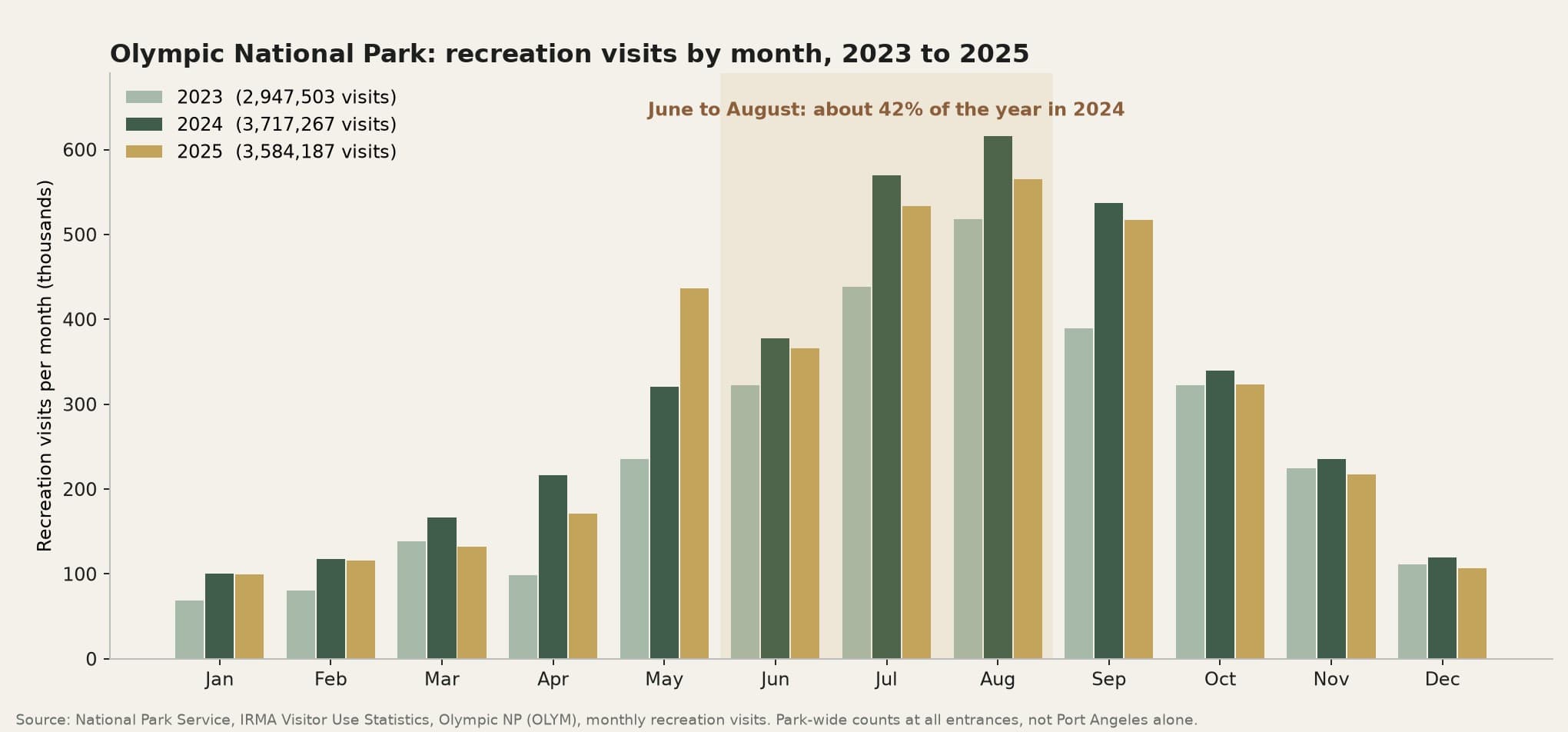
Olympic National Park recorded 3,717,267 recreation visits in 2024, a record, and about 42% of them came in June to August.[3] Those are park-wide counts at every entrance, not Port Angeles alone. We found no published count for the Hurricane Ridge entrance by itself.
When the Park limited Hurricane Ridge to 345 vehicles a day after the Day Lodge fire, it reported that the quota was reached as early as 10:00 AM in the first week and that "wait times to enter have varied between no wait time and 1.5 hours."[4] Hurricane Ridge is "17 miles south of Port Angeles on Hurricane Ridge Road, off Mount Angeles Road."[5]
On safety, the City's Local Road Safety Plan says pedestrian and bicycle crashes in Port Angeles "are primarily clustered on the US 101 corridor, 1st Street and Front Street," and notes angle crashes at the signal at Race Street and First Street where a driver did not stop for a red light.[6]
What the record does not show
We did not find an on-record statement from WSDOT, a County commissioner or a 24th District legislator about the Front Street to Race Street Park traffic problem, and no official has proposed a tunnel. The record shows the City and the Park Service treating Race Street as a busy Park gateway and improving it at the surface. The tunnel is Third Harvest's idea.
The route on real ground
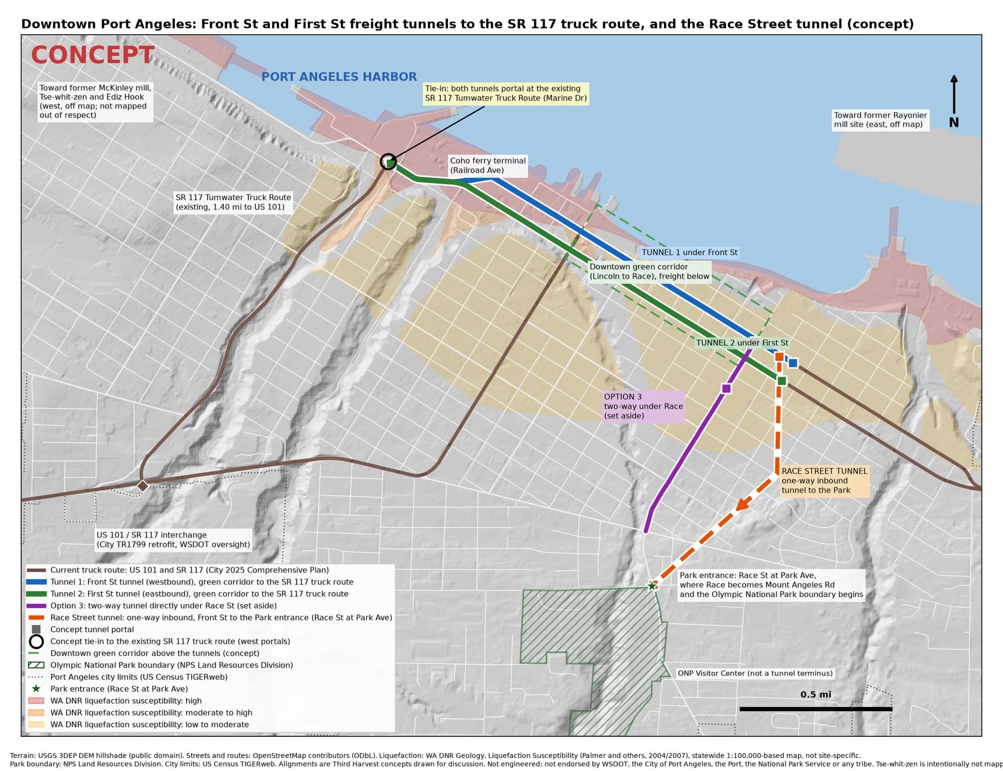
The line was drawn on USGS elevation data and OpenStreetMap street centerlines.[12, 18] It starts in the Front Street approach area just east of Race Street and ends at a portal on the City side of Park Avenue, about 250 feet short of the Olympic National Park boundary, so the tunnel stays inside city limits and off Park land.[10, 11] The Park's address is 600 E. Park Avenue,[9] and the Visitor Center is about 1,000 feet farther up Mount Angeles Road.
A tunnel straight under Race Street does not work. Race climbs at a fairly even 3 to 6%, close to the steepest grade a road tunnel should have, so a tunnel directly beneath it never gets deep enough to be enclosed. The concept line takes one gentle bend east of Race, up to about 0.3 mile from the street, which keeps a 6% roadway under the ground the whole way. That puts it under private blocks east of Race, so it would need subsurface easements and close control of settlement.
Along the concept line, Washington DNR maps the surface as low to moderate liquefaction susceptibility for about 29% of the length and very low to low, or very low, for the rest.[13] That is far firmer ground than the downtown waterfront.
Depth, grade and how it would be built
- Length: about 5,100 feet, just under a mile.
- Climb: about 200 feet, from roughly 90 feet above sea level on Front Street to roughly 290 feet at Park Avenue.
- Grade: up to 6%, which this concept treats as the upper limit for a road tunnel. Ordinary design practice prefers 4% or less, so a steeper tunnel needs extra attention to truck speeds, ventilation and braking.[14]
- Depth: the roadway is at most about 75 feet below the ground above it.
- Construction: mostly a shallow tunnel section (about 4,200 feet) built with ground improvement, short cut-and-cover boxes at the portals (about 260 feet), only about 130 feet at full bored cover, and open approach ramps of about 490 feet in all.
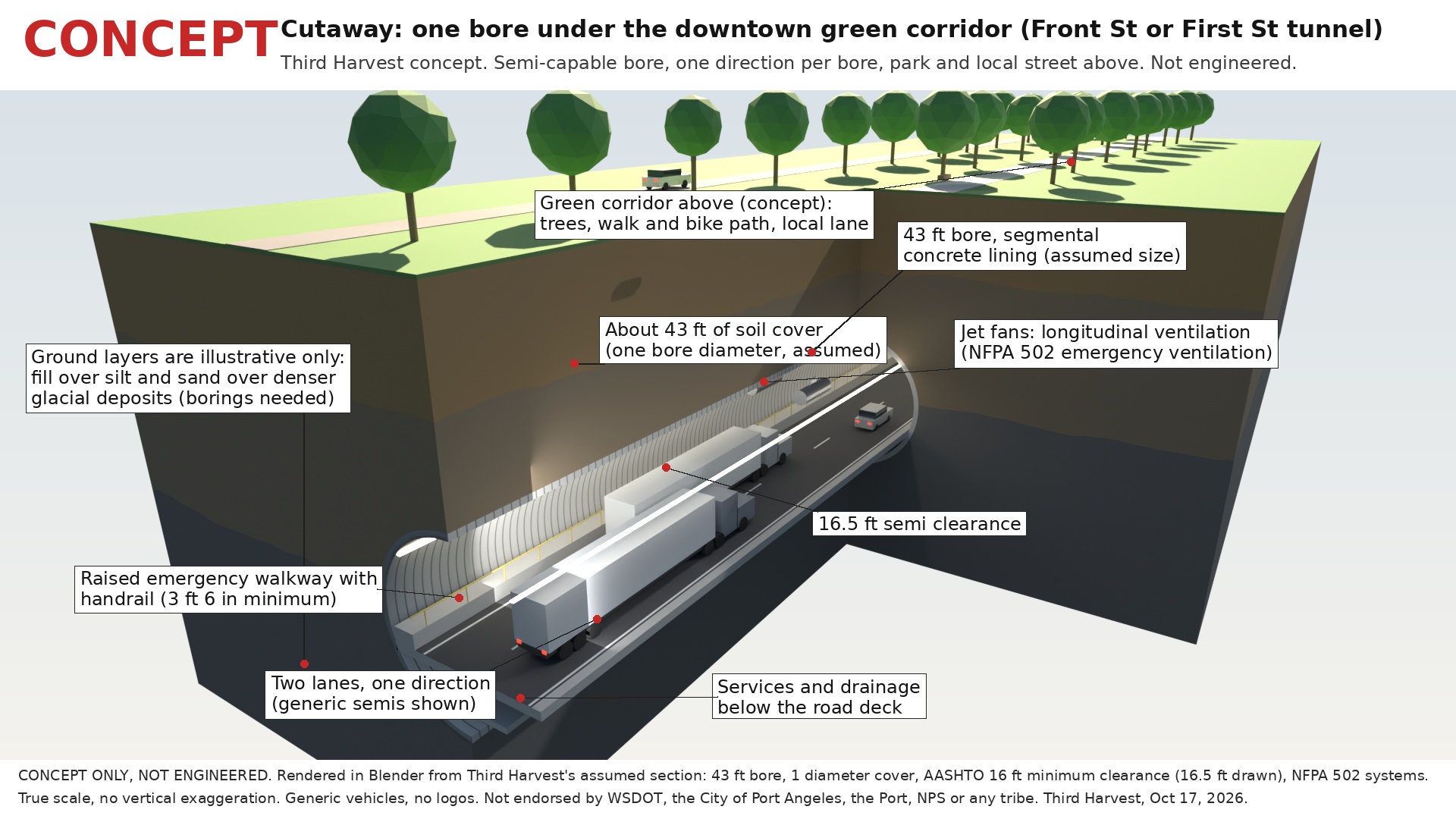
- Size: one bore, about 43 feet across on the outside, two lanes in one direction, with 16.5 feet of clearance. These are concept assumptions.
Because the line follows the ground closely, there is no earth mound to build and almost no deep boring. That is what ending at the Park entrance, rather than at the Visitor Center farther up the hill, makes possible.
How a visit would work
- 1
Arrive on US 101
A visitor heading for the Park comes into town westbound on US 101 along Front Street.
- 2
Peel off before Race Street
Park traffic splits from through traffic in the Front Street approach area and enters the one-way tunnel.
- 3
Climb under the town
About a mile inside, at a steady grade, with no signals, crossings or turning traffic.
- 4
Arrive at the Park entrance
The portal opens on the City side of Park Avenue at Race Street, where Mount Angeles Road begins. Wayfinding and shuttle stops would be planned with the Park.
- 5
Head home on Race Street
Outbound trips use Race Street at the surface, helped by an outbound lane, timed signals or shuttle priority.
- 6
Race Street gets its town back
With the summer queue underground, the surface street can serve walking, biking, transit and local trips, as the City intends.
ConceptEvery step above is a concept. Lane splits, signal timing and Park operations would be designed with the City, WSDOT and the National Park Service.
How it fits with the downtown tunnels
The Race Street tunnel is one of three connected concepts under Port Angeles. The other two are the Front Street and First Street freight tunnels, which would carry US 101 through traffic and trucks under downtown to the existing SR 117 truck route. The City already states that freight to and from the east "is forced through downtown Port Angeles."[7] WSDOT counted about 34,000 vehicles a day on US 101 just east of downtown in 2025.[8]
- Shared portal area. The Race Street tunnel's lower portal sits inside the Front Street tunnel's east approach. Park traffic would split off before the freight tunnel dives. This needs a joint design.
- A tight crossing. Just south of its lower portal, the Race Street tunnel passes under First Street inside the First Street tunnel's east ramp, with only about 26 feet between the two roadways in this rough model. It would take a flat-roofed box designed with that ramp, or moving one of the portals. This is not resolved.
- Built on its own. The Race Street tunnel does not depend on the freight tunnels being built first, but it is easier if the portal area on Front Street is planned once.
What would have to be true
- WSDOT. US 101 is a state highway, so any change to how traffic leaves it on Front Street is WSDOT's decision.
- The City of Port Angeles. The tunnel runs inside city limits and under City streets and private blocks, beside the City's own Race Street rebuild.[1]
- The National Park Service as partner at the entrance. The tunnel ends just outside the Park, but every vehicle that leaves it enters the Park within about 250 feet, so entrance operations, any vehicle limits and shuttles would be planned together.
- The Lower Elwha Klallam Tribe. Port Angeles stands in Klallam homelands, and the Tribe's village and burial ground at Tse-whit-zen, where the state stopped a waterfront project in 2004, is a reminder that digging here starts with consultation, before design.[16, 17]
- Engineering and review. Geotechnical borings along the whole line, easements under private property, settlement control, NEPA and SEPA environmental review, and cultural resources review under Section 106.
- Money. For scale only, Seattle's SR 99 bored tunnel, including access, cost about $2.05 billion for a bore of about 1.76 miles.[15] The Race Street tunnel is shorter and mostly shallow, but it would still be a major public project.
Nobody has been contacted, and nothing here implies the involvement or endorsement of WSDOT, the City, the National Park Service, the Tribe or any company.
Next steps Third Harvest would take
- Ask the City for summer turning counts at Front, First, Eighth and Lauridsen on Race Street, and the Park for any entrance counts it can share.
- Commission a desk-level feasibility review of the line by a licensed tunnel engineer, including the crossing under First Street.
- Invite the Lower Elwha Klallam Tribe to a listening conversation before any public design work.
- Brief WSDOT Olympic Region and the City's Public Works department on the concept, alongside the downtown freight tunnels.
Sources
Free public sources, checked October 2026. Numbers in brackets in the text point here.
- 1.City of Port Angeles, Race Street Complete Design and Construction Phase One (TR0209)
- 2.Peninsula Daily News, "Race Street improvement project gaining momentum in Port Angeles," Oct 30, 2015
- 3.National Park Service, IRMA Visitor Use Statistics, Olympic National Park
- 4.National Park Service, "Hurricane Ridge vehicle capacity to increase," Jul 5, 2023
- 5.National Park Service, Visiting Hurricane Ridge
- 6.City of Port Angeles, Local Road Safety Plan, updated May 2024
- 7.City of Port Angeles, RFQ TR1799, SR 117 Truck Route at US 101 Interchange Improvements, Apr 10, 2026
- 8.WSDOT, Traffic Counts (2025 annual average daily traffic)
- 9.National Park Service, Olympic National Park contacts (600 E. Park Avenue)
- 10.National Park Service, Land Resources Division boundary data
- 11.US Census Bureau, TIGERweb incorporated places (Port Angeles city limits)
- 12.USGS 3D Elevation Program
- 13.Washington DNR Geology, Ground Response (liquefaction susceptibility)
- 14.FHWA, Technical Manual for Design and Construction of Road Tunnels, Civil Elements
- 15.FHWA Center for Innovative Finance, Alaskan Way Viaduct (SR 99) project profile
- 16.Lower Elwha Klallam Tribe, Tse-whit-zen
- 17.HistoryLink Essay 7344, the state halts the Port Angeles graving dock project, Dec 2004
- 18.OpenStreetMap contributors (street centerlines, ODbL)
Related
Concept only. Nothing on this page has been approved by, or agreed with, any agency, tribe or company. Nobody was contacted to prepare it.